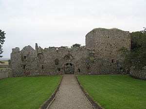
Pitsligo Castle
| Pitsligo castle | |
|---|---|
| Aberdeenshire, Scotland | |
 | |
| Coordinates | 57°41′32″N 2°06′25″W / 57.6923°N 2.1069°W |
| Site information | |
| Condition | Ruin |
| Site history | |
| Built | 15th century |
Pitsligo Castle is a ruined castle half a mile east of Rosehearty, Aberdeenshire, Scotland. It was described by W. Douglas Simpson as one of the nine castles of the Knuckle, referring to the rocky headland of north-east Aberdeenshire.[1]
It originated as a 15th-century keep. There is an arched gateway in the west wall of the outer court, with the date 1656 and the arms of the Forbeses and Erskines. In the inner court the date is shown as 1663. At the north-east angle of the courtyard there is a tall flanking drum-tower. The main tower had three vaulted stories, but almost all above the lowest has disappeared. There is a stair tower at the north-east corner which is better preserved. There are panels dated 1577 over the courtyard doorway.
It is listed by Historic Scotland as a scheduled monument.[2]
See also
References
- ^ Simpson, W.D. (1949). "Cairnbulg Castle, Aberdeenshire" (PDF). Proceedings of the Society of Antiquaries of Scotland. 83: 32–44.
- ^ "Pitsligo Castle SM6146". Historic Environment Scotland. Retrieved 20 September 2017.
