
Search results
Did you mean: big pine faculty
The page "Big Pine Faults" does not exist. You can create a draft and submit it for review or request that a redirect be created, but consider checking the search results below to see whether the topic is already covered.
 vents at Big Pine are associated with faults such as the Owens Valley fault, the Sierra Nevada fault and the White Mountains fault; faults have offset...15 KB (1,791 words) - 17:23, 28 January 2024
 Fault. To the west of Big Pines is Jackson Lake, a sag pond located on the San Andreas Fault. The lake is home to many recreational activities. Big Pines...5 KB (220 words) - 06:59, 10 November 2023
 intrusions. Several prominent faults exist, including the Big Pine Fault, which trends eastward towards the San Andreas Fault about forty miles away. The...8 KB (785 words) - 10:43, 12 October 2023
 Andreas Fault system in California. It is bounded on the south by the Big Pine Fault in Ventura County and on the west by the Nacimiento Fault. It was...4 KB (490 words) - 21:15, 1 July 2021
 Cumberland Mountains (section Pine Mountain)Syncline. Several gaps occur along Pine Mountain, and these are usually caused by erosion along cross-cutting faults. These gaps include the gap at High...10 KB (1,117 words) - 17:35, 4 September 2023
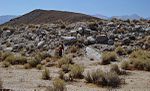 1872 Owens Valley earthquake (redirect from Great Lone Pine earthquake)(11 to 12 m) on the Lone Pine Fault and part of the Owens Valley Fault. These faults are part of a twin system of normal faults that run along the base...9 KB (825 words) - 21:30, 4 August 2024
 the juncture of the San Andreas with the Garlock Fault and Big Pine Fault. Different areas of the fault have different types of separation: normal or reverse...7 KB (841 words) - 16:09, 20 May 2024
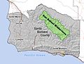 sedimentary, and are of Miocene and Cretaceous age. Both the Nacimiento and Big Pine Faults run through the wilderness, roughly parallelling the Sierra Madre and...8 KB (960 words) - 00:24, 1 November 2021
 for Thomas Dibblee. (with Mason L. Hill) “San Andreas, Garlock, and Big Pine faults, California,” Geological Society of America Bulletin, April 1953, p...7 KB (782 words) - 12:49, 5 July 2024
 Transverse Ranges (section Faults)of the western segment the bounding faults are left slip Santa Ynez and Pine Mountain Faults. The San Gabriel Fault and San Andreas bound the central segment...27 KB (3,118 words) - 14:21, 24 July 2024
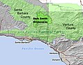 nearby San Andreas Fault, which is only about 12 miles from the wilderness boundary. The Pine Mountain Fault splits off from the Big Pine; it is visible along...7 KB (756 words) - 08:48, 11 November 2022
 multiple names: authors list (link) McLaughlin, Mark. "Living with Faults: The 1872 Lone Pine Earthquake". Sierra College Ejournals. Sierra College Press. Retrieved...31 KB (3,565 words) - 00:21, 18 May 2024
 slivered by motion on the San Andreas and associated fault systems. The Palo Colorado and Church Creek faults are prominent features influencing the linear northwest–southeast...193 KB (20,234 words) - 23:17, 14 August 2024
 Piercing point (category Seismic faults)Hill, M.L., and Dibblee, T.W., Jr., 1953, San Andreas, Garlock, and Big Pine faults, California-a study of the character, history, and tectonic significance...6 KB (766 words) - 13:59, 26 May 2024
- displaced to its present position by a series of thrust and strike-slip faults. The geology of this region has proved vastly important in determining the...8 KB (872 words) - 06:23, 14 February 2024
 are the small unincorporated communities of Mount Baldy, Wrightwood, Big Pines and Lytle Creek. Melting snow and rain runoff on the south side of the...29 KB (3,411 words) - 08:59, 26 May 2024
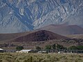
 south to north. The range's broad southern end is near the community of Big Pine, where Westgard Pass and Deep Springs Valley separate it from the Inyo...13 KB (1,139 words) - 07:06, 14 August 2024
 The Pine Ridge Indian Reservation (Lakota: Wazí Aháŋhaŋ Oyáŋke), also called Pine Ridge Agency, is an Oglala Lakota Indian reservation located in the...122 KB (14,158 words) - 15:42, 20 August 2024
- 2007). "Aeromagnetic mapping of the structure of Pine Canyon caldera and Chisos Mountains intrusion, Big Bend National Park, Texas". Geological Society...2 KB (227 words) - 04:39, 25 August 2024
 the Nevada/California border. Geologic faults punctuate the range, chief among them the Wasatch Fault. These faults also formed the Timpanogos Cave. A series...22 KB (2,486 words) - 21:55, 14 August 2024


- The Big Four (1927) by Agatha Christie 4179647The Big Four1927Agatha Christie Layout 2 CHAPTER XVII Number Four Wins a Trick From our quiet retreat
- Pine: Hey, hey! Ain't you curious at have I get around so fast? C, I have these Rocket Boots, and they... Mr. Incredible: Go home, Buddy. Buddy Pine:
- years later, detachment faults caused the upper part of the caldera to slide 20 miles off the lower region due to detachment faults (Geocoaching, 2013).