
Search results
The page "East+Coolgardie+Goldfield" does not exist. You can create a draft and submit it for review or request that a redirect be created, but consider checking the search results below to see whether the topic is already covered.
 goldfields were gazetted with Coolgardie as reference point: Coolgardie Goldfield (1894) East Coolgardie Goldfield (1894) North Coolgardie Goldfield (1895)...15 KB (1,438 words) - 01:49, 19 April 2024
- Broad Arrow Goldfield Coolgardie Goldfield East Coolgardie Goldfield North East Coolgardie Goldfield North Coolgardie Goldfield Yilgarn Goldfield In the 1890s...6 KB (544 words) - 14:20, 12 January 2024
 Australian gold rushes (redirect from Gympie goldfield)discovery of the Yilgarn goldfields. The Yilgarn Rush died out when news arrived of the rich discovery of gold to the east at Coolgardie in September 1892....177 KB (20,136 words) - 11:36, 22 June 2024
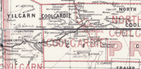 the district included Kalgoorlie, Boulder, and the lucrative East Coolgardie goldfield. It existed for one term of parliament, and was represented in...2 KB (88 words) - 12:13, 6 May 2024
- even for adult sheep. In the 1890s the goldfields term was used for country between Southern Cross and Coolgardie; however, as the gold fields extended...9 KB (898 words) - 22:00, 6 July 2024
- Goldfields Woodlands National Park is a national park in the Goldfields-Esperance region of Western Australia, 474 km (295 mi) east of Perth and 120 km...3 KB (244 words) - 22:00, 6 July 2024
 North-East Coolgardie was an electoral district of the Legislative Assembly in the Australian state of Western Australia from 1897 to 1901. The district...3 KB (164 words) - 01:53, 10 June 2022
 The Shire of Coolgardie is a local government area in the Goldfields–Esperance region of Western Australia, lying roughly west and south of the city of...9 KB (658 words) - 22:06, 6 July 2024
 located in the Goldfields-Esperance region of Western Australia along the Coolgardie-Esperance Highway, 726 kilometres (451 mi) east of Perth and 278...8 KB (706 words) - 17:45, 18 May 2024
- mining geology of the Kanowna main reef line, Kanowna, North-East Coolgardie Goldfield (Perth, W.A., Government Printer, 1912) Geological investigations...6 KB (560 words) - 03:56, 19 March 2024
 Manning Nature Reserve, Jilbadji Nature Reserve, and Goldfields Woodlands National Park in western Coolgardie, and Dundas Nature Reserve which extends south...7 KB (536 words) - 07:22, 17 April 2024
- Kanowna Road District (redirect from North East Coolgardie Road District)government area on the Western Australian goldfields. It was established on 19 June 1896 as the North East Coolgardie Road District, providing basic local...2 KB (245 words) - 22:05, 6 July 2024
 near Mount Charlotte, less than 40 kilometres from the existing Coolgardie Goldfields. Hannan, Flanagan and Shea were following a large number of prospectors...9 KB (1,137 words) - 16:24, 8 December 2023
- present and former gold-mining area east of Perth. The region encompasses the towns of Kalgoorlie, Boulder, Coolgardie, Kambalda, Southern Cross and other...8 KB (872 words) - 21:58, 6 July 2024
 Kalgoorlie (category Goldfields–Esperance)soon replaced Coolgardie as the largest settlement on the Eastern Goldfields. Kalgoorlie is the ultimate destination of the Goldfields Water Supply Scheme...54 KB (5,354 words) - 13:43, 22 July 2024
 Retrieved 17 May 2016 – via National Library of Australia. "GOLDFIELDS REPRESENTATION". Coolgardie Miner. Vol. X, no. 2801. Western Australia. 8 December 1903...28 KB (1,716 words) - 22:07, 6 July 2024
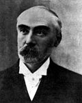 C. Y. O'Connor (category Goldfields Water Supply Scheme)construction of Fremantle Harbour, thought to be impossible, and the Goldfields Water Supply Scheme. O'Connor was born in Gravelmount House, a small country...18 KB (1,863 words) - 05:06, 30 July 2024
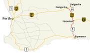 in a north–south direction linking the state's Eastern Goldfields to the coast. The Coolgardie–Norseman stretch (National Highway 94) forms part of the...33 KB (3,124 words) - 03:18, 8 February 2023
- Wangkatha (category Goldfields–Esperance)Australian peoples of the Eastern Goldfields region. The Wangkatja language groups cover the following towns: Coolgardie, Kalgoorlie, Menzies, Leonora and...9 KB (963 words) - 03:28, 30 July 2024
 Great Eastern Highway (section East to Kalgoorlie)of Coolgardie to Kalgoorlie. Traffic in the Goldfields was light, with an average daily traffic of 44 vehicles between Southern Cross and Coolgardie, and...80 KB (6,847 words) - 00:04, 17 June 2024


- CHAPTER XXI. THE GOLDFIELDS. 1893 TO 1897. TRUTHFULNESS OF REPORTS—DIFFICULTIES OF NARRATIVE—WATER QUESTION—STAMPEDE FOR COOLGARDIE, 1893—DESULTORY
- system. But Murphy's law could come to bear and during the an outage near Coolgardie in April 1935, when Geraldton wireless was called to assist, it was found