
Search results
The page "Muchinga Escarpment" does not exist. You can create a draft and submit it for review or request that a redirect be created, but consider checking the search results below to see whether the topic is already covered.
 southwest to northeast and is located on both sides of the Muchinga Mountains (Muchinga Escarpment), which serve as a divide between the drainage basins of...14 KB (1,375 words) - 08:51, 30 July 2024
 escarpment extends northward to form the border between Mozambique and Zimbabwe, continuing on beyond the Zambezi river valley to form the Muchinga Escarpment...16 KB (1,778 words) - 14:10, 10 July 2024
 as well, their ranges are separated by relief features or by the Muchinga escarpment. Not many fossils of the waterbuck have been found. Fossils were...37 KB (4,503 words) - 17:53, 25 August 2024
 Geography of South Africa (section Great Escarpment)the Great Escarpment which extends northwards to about 10° south of the Equator (i.e. into Angola in the west, and the Muchinga Escarpment in Zambia in...50 KB (5,916 words) - 11:56, 26 May 2024
 to a large group of Bantu peoples, primarily in the Northern, Luapula, Muchinga and the northern Central Province of Zambia. The Bemba entered Zambia before...17 KB (2,228 words) - 14:08, 26 April 2024
 of the Kaombe River, this waterfall descends from the formidable Muchinga Escarpment in a series of stages, collectively forming a mesmerizing drop of...5 KB (491 words) - 14:55, 19 January 2024
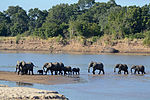 South Luangwa National Park (category Geography of Muchinga Province)Red Sea down to the Pungwe River mouth in Mozambique. The Muchinga Escarpment in Muchinga and Central Provinces forms the park's western or north-western...7 KB (756 words) - 19:05, 23 July 2024
 Mpika (category Populated places in Muchinga Province)Railway about 5 kilometres (3 mi) away. Mpika is situated between the Muchinga Escarpment to the east and vast miombo plains to the west. The town has an estimated...12 KB (634 words) - 08:22, 22 May 2024
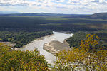 (62 mi) wide, with a north-west escarpment (Muchinga Escarpment) about 700 metres (2,300 ft) high, and a south-western escarpment about 450 metres (1,480 ft)...12 KB (1,348 words) - 23:40, 10 June 2024
 highlands: around Kambole and Mbala above Lake Tanganyika, (the Muchinga escarpment above the Luangwa valley, and the highlands along north-eastern border...26 KB (2,390 words) - 09:33, 30 July 2024
 Wildlife of Zambia (section Muchinga Province)and livestock grazing, and chitemene cultivation on the margins. Muchinga escarpment overlooking the Luangwa Valley: the rocky hills and scarps do not...27 KB (3,592 words) - 03:45, 15 July 2024
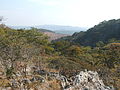 portion of Mpika District (Northern Province) westwards throughout the Muchinga Escarpment uplands of Central Province to the vicinity of Kapiri Mposhi. It...7 KB (938 words) - 19:39, 22 February 2023
 the Kundelungu plateau, Shaba Province) and in Zambia (along the Muchinga escarpment in Luapula and Northern provinces). A subpopulation is also found...39 KB (1,107 words) - 14:51, 24 August 2024
- North Luangwa National Park (category Geography of Muchinga Province)boundary is the Luangwa River, while it rises to cover a stretch of the Muchinga Escarpment to the west. The Mwaleshi River flows east–west through the Centre...5 KB (439 words) - 22:56, 30 October 2023
- the Kundelungu plateau, Shaba Province) and in Zambia (along the Muchinga escarpment in Luapula and Northern provinces). A subpopulation is also found...3 KB (297 words) - 14:45, 17 January 2024
- 500m deep gash, known as The Wonder Gorge, through the lip of the Muchinga Escarpment (viewed from Bell's Point). The antenna atop the Taipei 101 skyscraper...15 KB (2,111 words) - 13:12, 17 February 2024
- except areas close to the Zambezi, Lunsemfwa and Kafue rivers 12 —the Muchinga escarpment in Central and Northern Provinces 13 —most of Eastern Province except...18 KB (2,569 words) - 20:05, 12 June 2024
 in a northeasterly direction, between the Bangweulu Flats and the Muchinga Escarpment, towards an area a few dozen kilometres west of Isoka along the road...21 KB (2,557 words) - 12:11, 1 August 2024
- Lavushi Manda National Park (category Tourist attractions in Muchinga Province)Manda lies on the plateau area of Lavushimanda District between the Muchinga Escarpment and the alluvial flats of the Bangweulu floodplain. The scenery is...30 KB (3,377 words) - 11:50, 25 February 2024
 The Tazara enters northeastern Zambia in the Nakonde District, in the Muchinga Province, and heads southwest to Kasama. It then turns due south and crosses...64 KB (7,077 words) - 20:28, 23 August 2024


