
Search results
The page "Sakarya Valley" does not exist. You can create a draft and submit it for review or request that a redirect be created, but consider checking the search results below to see whether the topic is already covered.
 marks, boxes, or other symbols instead of cuneiform script. The Sakarya (Turkish: Sakarya Nehri; Hittite: 𒀀𒇉𒊭𒄭𒊑𒅀, romanized: Šaḫiriya; Greek: Σαγγάριος...5 KB (596 words) - 07:15, 30 May 2024
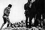 Kütahya in Turkey. Following the attrition battle on the Sakarya River (Battle of Sakarya) in August–September 1921, the Greek Army of Asia Minor under...35 KB (4,553 words) - 16:21, 30 August 2024
 Bithynia (category History of Sakarya Province)Strabo, Bithynia was bounded on the east by the river Sangarius (modern Sakarya river), but the more commonly received division extended it to the Parthenius...16 KB (1,666 words) - 03:26, 21 June 2024
 Battle of Sakarya National Historic Park (Turkish: Sakarya Meydan Muharebesi Tarihi Milli Parkı), established on February 8, 2015, is a protected area...3 KB (107 words) - 14:26, 20 June 2023
 Eskişehir. Their advance was checked by Turkish forces at the Battle of the Sakarya in 1921. The Greek front collapsed with the Turkish counter-attack in August...186 KB (21,850 words) - 07:41, 7 September 2024
 is now the modern Turkish village of Ballıhisar, in a tributary valley of the Sakarya River on the high Anatolian plateau at ca. 950 m above sea level...24 KB (3,081 words) - 22:04, 23 July 2024
 150 m (500 ft) over the left bank of the Ankara River, a tributary of the Sakarya River. The hill remains crowned by the ruins of Ankara Castle. Although...124 KB (12,208 words) - 02:32, 2 September 2024
 Eskişehir is sited on the banks of Porsuk River, which flows into the Sakarya River. Porsuk Dam, located near the Eskişehir-Kütahya border controls the...24 KB (1,747 words) - 01:02, 3 September 2024
 and drove on Ankara. The Turks checked their advance in the Battle of Sakarya and counter-attacked in the Great Offensive, which expelled Greek forces...157 KB (17,369 words) - 15:37, 23 August 2024
 8th century BC, the Phrygian kingdom with its capital at Gordium in the upper Sakarya River valley expanded into an empire dominating most of central and western Anatolia...52 KB (6,269 words) - 18:56, 10 August 2024
 bordered to the west by Sakarya, to the northeast by Zonguldak, and to the east by Bolu. It opens to the Black Sea with the valley of Büyük Melen on the...11 KB (810 words) - 08:35, 27 August 2024
- 4,822 Region of Nicaragua. Bohol 4,820.95 Province of the Philippines. Sakarya Province 4,817 Province of Turkey. County Kerry 4,807 County in the Republic...87 KB (460 words) - 03:21, 8 May 2024
 vicinity of Polatlı district. Gordion's location at the confluence of the Sakarya and Porsuk rivers gave it a strategic location with control over fertile...40 KB (4,424 words) - 18:56, 10 August 2024
 by the Porsuk dam forming large reservoirs. The Porsuk flows into the Sakarya River near the town of Polatlı, ancient Gordium. Wikimedia Commons has...1 KB (126 words) - 18:56, 11 March 2023
 begins gas production from Sakarya field in Black Sea". 21 April 2023. Archived from the original on 10 March 2024. "Sakarya Gas Field Development, Black...293 KB (26,024 words) - 16:47, 5 September 2024
 province in midwest Turkey, neighboring Bursa to the west, Kocaeli and Sakarya to the north, Bolu to the east, Eskişehir to the southeast and Kütahya...8 KB (537 words) - 14:35, 18 August 2024
 Mountains Derebucak Çamlık Caves Lake Beyşehir Independence Path Battle of Sakarya Mount Sarıçalı Soğuksu Sultan Reedy Yozgat Pine Grove Eastern Anatolia...14 KB (1,386 words) - 10:19, 18 August 2024
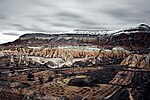 plateaus and high hills, dissected by streams and river valleys carved out by the water, the valleys having steeply sloping sides. Part of this rugged area...7 KB (567 words) - 04:01, 21 August 2024
 geographic context. From west to east, the main rivers of the region are the Sakarya (824 km), the Kızılırmak River (1355 km, the longest river of Turkey),...28 KB (4,103 words) - 20:14, 12 June 2024
 Matarlı Menderes Narlıdere Örencik Örnekköy Osmaniye Piyadeler Şahyar Sakarya Sarıpınar Sarısu Selce Serinköy Serinyayla Şeyhsinan Sobran Soğanlı Soğuksu...21 KB (2,503 words) - 03:58, 21 August 2024


- Kiitahya, Malatya, Manisa, Mardin, Muğla, Muş, Nevşehir, Niğde, Ordu, Rize, Sakarya, Samsun, Siirt, Sinop, Sivas, Tekirdağ, Tokat, Trabzon, Tunceli, Urfa,