
Search results
The page "Umatilla Rapids" does not exist. You can create a draft and submit it for review or request that a redirect be created, but consider checking the search results below to see whether the topic is already covered.
 to a new boat above the rapids. The site was first known as Umatilla Landing, then Umatilla City, then Columbia, then Umatilla City once again over the...23 KB (2,036 words) - 19:17, 4 November 2023
 navigation at the rapids. In 1911 a "large reef" was removed from the "middle rapids". The rapids were submerged in 1971 under Lake Umatilla, the reservoir...45 KB (6,928 words) - 18:17, 22 March 2024
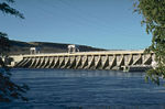 McNary Dam (category Buildings and structures in Umatilla County, Oregon)that lifts boats an average of 75 feet (23 m). The dam flooded the Umatilla Rapids, forming a reservoir called Lake Wallula. The lake extends 64 miles...7 KB (623 words) - 15:57, 31 January 2024
 serious damage while running downstream through Umatilla Rapids, which were located two miles east of Umatilla, Oregon. The steamer first hit one set of rocks...18 KB (1,708 words) - 00:25, 16 April 2023
 that Relief could not ascend the Umatilla Rapids, upstream from the mouth of the Umatilla River and the town of Umatilla, Oregon. A non-contemporaneous...34 KB (3,558 words) - 15:30, 2 June 2022
 Celilo Falls (redirect from Five Mile Rapids)Nation, the Confederated Tribes of Warm Springs, and the Walla Walla, Umatilla, and Cayuse, which guaranteed the tribes' ancient "right of taking fish...29 KB (3,068 words) - 19:10, 19 April 2024
 The Cascades Rapids (sometimes called Cascade Falls or Cascades of the Columbia) were an area of rapids along North America's Columbia River, between the...7 KB (812 words) - 19:32, 16 July 2024
 the following local rivers were derived from Sahaptin: the Klickitat, Umatilla, Walla Walla, Palouse, Yakima, Satus, Toppenish, Tieton, and Wenatchee...24 KB (2,950 words) - 03:52, 1 July 2024
 Grant County - north Franklin County - northeast Walla Walla County - east Umatilla County, Oregon - southeast Morrow County, Oregon - southwest Klickitat...26 KB (2,575 words) - 03:38, 16 July 2024
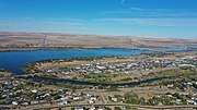
 The Umatilla Site (Smithsonian trinomial: 35UM1 and 35UM35) is an archaeological site near Umatilla, Oregon, United States. Situated on the shores of...3 KB (304 words) - 11:29, 11 January 2024
 The Umatilla National Forest, in the Blue Mountains of northeast Oregon and southeast Washington, covers an area of 1.4 million acres (5,700 km2). In descending...8 KB (655 words) - 16:57, 15 June 2022
 Idaho, Oregon, and Washington Skinpah (Skin) Tenino (Warm Springs Bands) Umatilla, Oregon Walla Walla, Washington Wanapum, Washington Yakama, Washington...23 KB (2,830 words) - 16:40, 4 June 2024
 (Lik-si-yu) (Weyíiletpuu – "Ryegrass People"), west bound there were found the Umatilla (Imatalamłáma) (Hiyówatalampoo/Hiyuwatalampo), Walla Walla, Wasco (Wecq’úupuu)...73 KB (9,224 words) - 00:33, 18 July 2024
 Metropolitan Statistical Area Sherman 1,870 823 Tillamook 27,390 1102 Umatilla 80,075 3215 Hermiston-Pendleton, OR Micropolitan Statistical Area Union...327 KB (1,443 words) - 12:13, 9 July 2024
 Eastern Oregon (category Geography of Umatilla County, Oregon)Burns, Hermiston, Pendleton, Boardman, John Day, La Grande, and Ontario. Umatilla County is home to the largest population base in Eastern Oregon, accounting...24 KB (2,303 words) - 03:58, 8 June 2024
 the Colville, Spokane, Coeur d'Alene, Yakama, Nez Perce, Cayuse, Palus, Umatilla, Cowlitz, and the Confederated Tribes of Warm Springs live along the US...193 KB (18,422 words) - 08:55, 17 July 2024
- John Day Dam and Lake Umatilla (Washington, Oregon) John Day River (Oregon) Willow Creek (Oregon) Rhea Creek Hinton Creek Umatilla River (Oregon) McNary...23 KB (1,609 words) - 19:52, 22 March 2024
 Tribes and Bands of the Yakima Nation, the Confederated Tribes of the Umatilla Indian Reservation, and the Nez Perce Tribe. Native Americans were accustomed...108 KB (14,288 words) - 12:05, 19 July 2024
 federal government sued the state along with the Yakama, Warm Springs, Umatilla, and Nez Perce tribes. The ruling issued by judge Robert C. Belloni in...5 KB (276 words) - 03:05, 13 September 2023
 The Umatilla National Wildlife Refuge is located on and around the Columbia River about 15 miles (24 km) northwest of Hermiston, Oregon and includes 8...3 KB (227 words) - 10:54, 7 June 2022


- the "John Day" and the "Umatilla "Rapids, both named after streams entering into the Columbia in the vicinity of the rapids. In very low stages of water