
File:Countriesbyfertilityrate.svg

Size of this PNG preview of this SVG file: 800 × 411 pixels. Other resolutions: 320 × 164 pixels | 640 × 329 pixels | 1,024 × 526 pixels | 1,280 × 657 pixels | 2,560 × 1,314 pixels | 863 × 443 pixels.
Original file (SVG file, nominally 863 × 443 pixels, file size: 1.72 MB)
| This is a file from the Wikimedia Commons. Information from its description page there is shown below. Commons is a freely licensed media file repository. You can help. |
Summary
| Description |
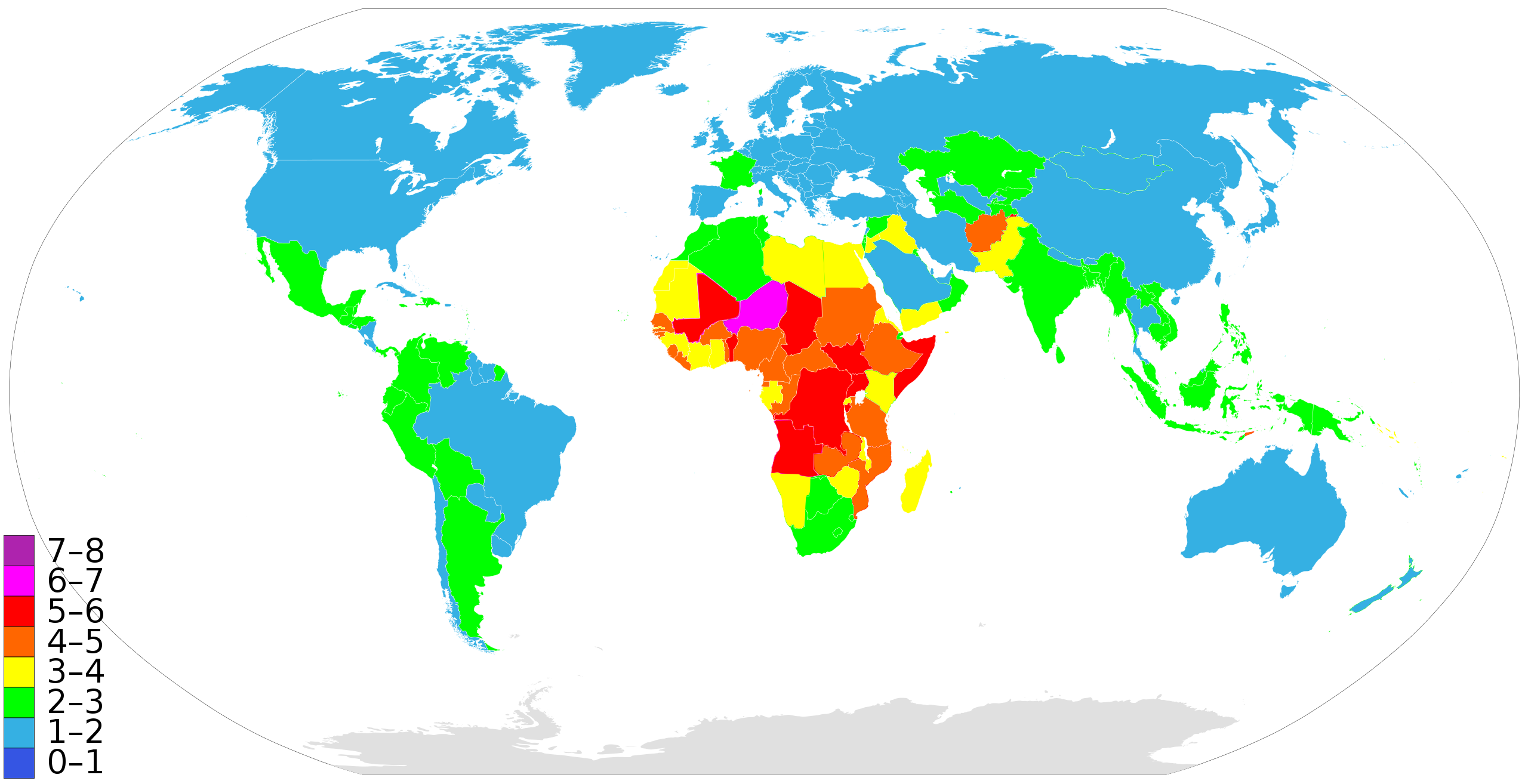
English: A world map showing countries by fertility rate. According to the The World FactBook (CIA), 2021 estimates.
Deutsch: Weltkarte mit den Staaten nach ihrer jeweiligen Fertilitätsrate eingefärbt - nach den Angaben vom 'The World FactBook' (CIA), Ausgabe 2021.
Español: Mapa del mundo con los países por índice de fertilidad. Periodo 2021
Português: Um mapa mundial identificando os países por índice de fertilidade. Período 2021
Català: Mapa del món amb tots els països del món per index de fertilitat. Període 2021
Русский: Карта мира по среднему количеству детей рождённых женщиной в течение жизни, по данным Всемирной книги фактов (ЦРУ), 2021
فارسی: نرخ کلی باروری در کشور های جهان، برآورد سال ۲۰۱۷
7–8 children
6–7 children
5–6 children
4–5 children
3–4 children
2–3 children
1–2 children
0–1 children |
| Date | 2009-07-07, last updated 2021 |
| Source | Own work – updated per The World FactBook (CIA) - https://www.cia.gov/library/publications/the-world-factbook/fields/2127.html |
| Author | Supaman89 |
Licensing
I, the copyright holder of this work, hereby publish it under the following licenses:
This file is licensed under the Creative Commons Attribution-Share Alike 3.0 Unported license.
- You are free:
- to share – to copy, distribute and transmit the work
- to remix – to adapt the work
- Under the following conditions:
- attribution – You must give appropriate credit, provide a link to the license, and indicate if changes were made. You may do so in any reasonable manner, but not in any way that suggests the licensor endorses you or your use.
- share alike – If you remix, transform, or build upon the material, you must distribute your contributions under the same or compatible license as the original.

|
Permission is granted to copy, distribute and/or modify this document under the terms of the GNU Free Documentation License, Version 1.2 or any later version published by the Free Software Foundation; with no Invariant Sections, no Front-Cover Texts, and no Back-Cover Texts. A copy of the license is included in the section entitled GNU Free Documentation License. |
You may select the license of your choice.
File history
Click on a date/time to view the file as it appeared at that time.
| Date/Time | Thumbnail | Dimensions | User | Comment | |
|---|---|---|---|---|---|
| 08:38, 10 March 2013 |  | 940 × 477 (1.74 MB) | Kohelet | USA 1-2 | |
| 04:16, 25 February 2013 |  | 863 × 443 (1.67 MB) | Spesh531 | fixed factbook info | |
| 07:29, 20 July 2012 |  | 940 × 477 (1.74 MB) | SeNeKa~commonswiki | update | |
| 16:00, 22 March 2012 |  | 940 × 477 (1.74 MB) | Kjrreid | moved background shape of "globe" back to where it ought to be -- behind the continents | |
| 05:56, 20 March 2012 |  | 940 × 477 (1.74 MB) | Innab | Updated with 2012 data from CIA World Factbook. See: https://www.cia.gov/library/publications/the-world-factbook/rankorder/2127rank.html | |
| 05:48, 20 March 2012 |  | 940 × 477 (1.74 MB) | Innab | Updated with 2012 data from CIA World Factbook. See: https://www.cia.gov/library/publications/the-world-factbook/rankorder/2127rank.html | |
| 20:02, 21 September 2011 |  | 940 × 477 (1.74 MB) | Innab | Updated with new 2011 data, per The World FactBook (CIA) - https://www.cia.gov/library/publications/the-world-factbook/rankorder/2127rank.html?countryName=United States&countryCode=us®ionCode=noa&rank=122#us | |
| 00:45, 20 July 2011 |  | 940 × 477 (1.74 MB) | Riffraffselbow | Added data Cyprus, Luxembourg, and Singapore. | |
| 14:23, 28 August 2010 |  | 940 × 477 (1.73 MB) | Ori Mosenzon | Just added information about Israel and the west bank | |
| 02:40, 8 July 2009 |  | 940 × 477 (1.73 MB) | Supaman89~commonswiki | {{Information |Description={{es|1=Una mapa mundial mostrando a los paises por indice de fertilidad.}} {{en|1=A world map showing countries by fertility rate.}} |Source=Own work by uploader |Author=Supaman89 |Date=7 de Julio del 2009 |Pe |
File usage
The following pages on the English Wikipedia use this file (pages on other projects are not listed):
Global file usage
The following other wikis use this file:
- Usage on ar.wikipedia.org
- Usage on ba.wikipedia.org
- Usage on be.wikipedia.org
- Usage on bg.wikipedia.org
- Usage on ca.wikipedia.org
- Usage on cs.wikipedia.org
- Usage on de.wikipedia.org
- Usage on el.wikipedia.org
- Usage on eo.wikipedia.org
- Usage on eo.wikiquote.org
- Usage on es.wikipedia.org
- Usage on eu.wikipedia.org
- Usage on fi.wikipedia.org
- Usage on fr.wikipedia.org
- Usage on he.wikipedia.org
- Usage on hi.wikipedia.org
- Usage on hr.wikipedia.org
- Usage on hu.wikipedia.org
- Usage on hy.wikipedia.org
- Usage on id.wikipedia.org
- Usage on it.wikipedia.org
- Usage on it.wikibooks.org
- Usage on it.wikiversity.org
- Usage on kn.wikipedia.org
- Usage on ko.wikipedia.org
- Usage on mg.wikipedia.org
- Usage on mk.wikipedia.org
- Usage on nl.wikipedia.org
View more global usage of this file.