
File:High Speed Railroad Map of the United States 2013.svg

Size of this PNG preview of this SVG file: 800 × 489 pixels. Other resolutions: 320 × 196 pixels | 640 × 391 pixels | 1,024 × 626 pixels | 1,280 × 782 pixels | 2,560 × 1,565 pixels | 975 × 596 pixels.
Original file (SVG file, nominally 975 × 596 pixels, file size: 232 KB)
| This is a file from the Wikimedia Commons. Information from its description page there is shown below. Commons is a freely licensed media file repository. You can help. |
Summary

|
This file may be updated to reflect new information. If you wish to use a specific version of the file without new updates being mirrored, please upload the required version as a separate file. |
| Description |
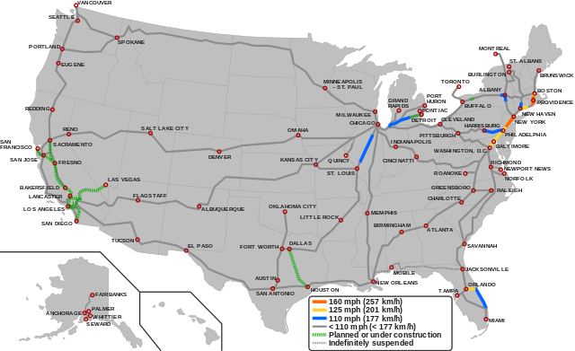
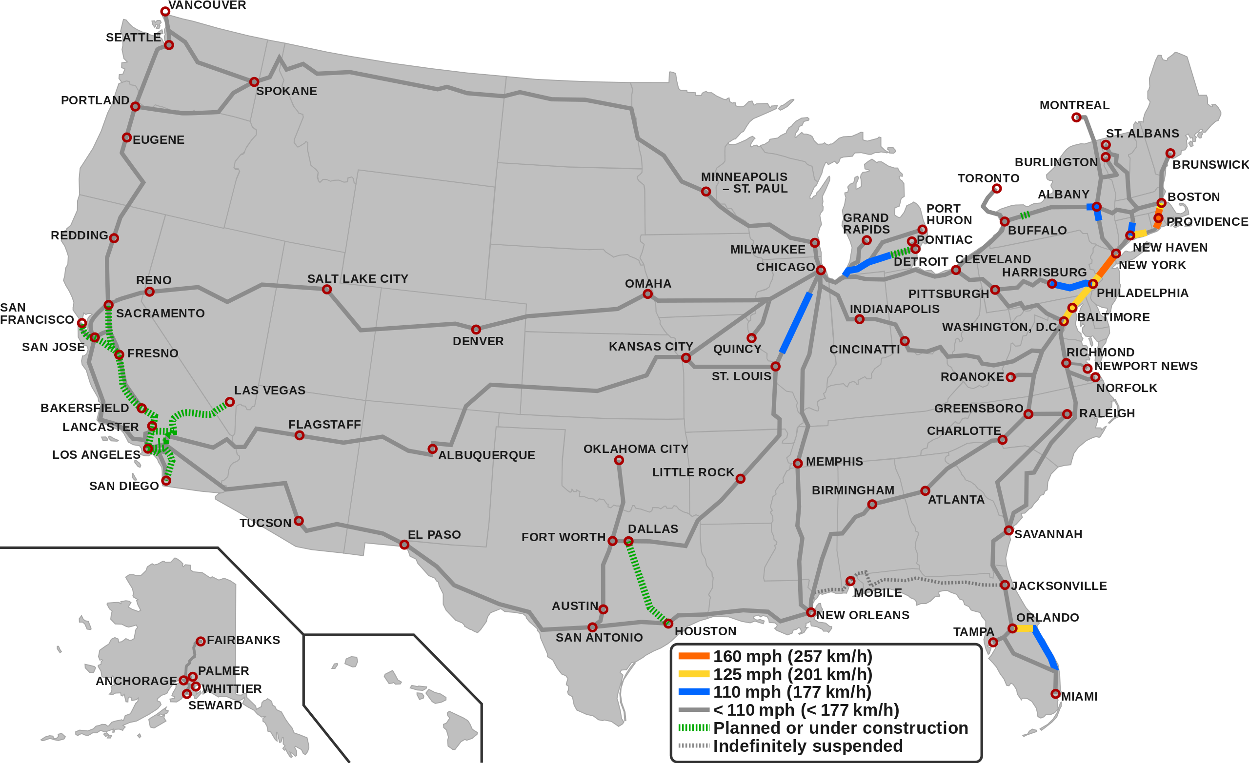
English (en): Map showing the high-speed rail network of the United States.1
160 mph (257 km/h) 125 mph (201 km/h) 110 mph (177 km/h) < 110 mph (< 177 Km/h) Planned/Under construction Indefinitely suspended
1 The map depicts the actual operational high-speed instead of the designed one which may be higher.
|
| Date | |
| Source |
|
| Author |
|
Licensing
This file is licensed under the Creative Commons Attribution-Share Alike 3.0 Unported license.
- You are free:
- to share – to copy, distribute and transmit the work
- to remix – to adapt the work
- Under the following conditions:
- attribution – You must give appropriate credit, provide a link to the license, and indicate if changes were made. You may do so in any reasonable manner, but not in any way that suggests the licensor endorses you or your use.
- share alike – If you remix, transform, or build upon the material, you must distribute your contributions under the same or compatible license as the original.
File history
Click on a date/time to view the file as it appeared at that time.
| Date/Time | Thumbnail | Dimensions | User | Comment | |
|---|---|---|---|---|---|
| current | 05:55, 6 December 2023 | | 975 × 596 (232 KB) | QuincyMorgan | Reverted to version as of 15:45, 2 December 2023 (UTC). State abbreviations overlap other stuff and make the map very hard to read |
| 05:24, 3 December 2023 |  | 975 × 596 (258 KB) | G-VarietyEditor | Added state labels and changed text fonts to Arial. | |
| 15:45, 2 December 2023 |  | 975 × 596 (232 KB) | Einsof | Adjust color contrast and line widths so that readers can actually see what is and is not HSR (the previous yellow was essentially invisible). Adjust city labels to try to make them readable without 500% zoom. Convert some effectively infinite-curvature smooth nodes into corner nodes so that they actually render (e.g.,at the Montreal terminus). Remove needless "Legend" text (if readers can't tell it's a legend, we've failed at making an understandable map). | |
| 14:18, 23 September 2023 |  | 940 × 598 (762 KB) | QuincyMorgan | Add HSR operation of Brightline, Michigan Line, and Lincoln Service. Add Ethan Allen Express to Burlington. Adjust some city labels. Make suspended service less prominent. Remove SMART and Dubuque line since other regional rail and proposed conventional speed lines aren't shown. | |
| 23:51, 25 January 2022 |  | 959 × 593 (643 KB) | Fluffy89502 | PA | |
| 05:23, 18 November 2021 |  | 959 × 593 (643 KB) | Fluffy89502 | SMART | |
| 18:48, 1 October 2021 |  | 959 × 593 (630 KB) | Fluffy89502 | San Diego correction | |
| 02:11, 29 September 2021 |  | 959 × 593 (630 KB) | Fluffy89502 | No line over Tehachapi Pass, Phoenix has no rail service, marked Lancaster & Flagstaff | |
| 22:11, 28 July 2021 |  | 959 × 593 (621 KB) | Iismitch55 | Added Roanoke VA branch, which is noted as major branch in sourced map | |
| 22:09, 28 July 2021 |  | 959 × 593 (615 KB) | Iismitch55 | Reverted to version as of 19:20, 3 June 2021 (UTC) | |
| 22:09, 28 July 2021 |  | 959 × 593 (621 KB) | Iismitch55 | Added Roanoke VA branch, which is noted as major branch in sourced map | |
| 22:04, 28 July 2021 |  | 959 × 593 (615 KB) | Iismitch55 | Reverted to version as of 19:20, 3 June 2021 (UTC) | |
| 21:52, 28 July 2021 |  | 959 × 593 (621 KB) | Iismitch55 | Added Roanoke VA branch, which is noted as major branch in sourced map | |
| 19:20, 3 June 2021 |  | 959 × 593 (615 KB) | Fluffy89502 | Rancho Cucamonga agreement w/ XpressWest | |
| 08:48, 17 February 2021 |  | 959 × 593 (615 KB) | Iismitch55 | New Jersey High Speed Rail improvements considered complete by Amtrak. Updated construction color on Keystone corridor to match key. | |
| 21:03, 8 July 2020 |  | 959 × 593 (615 KB) | Colin dm | Fixed issue where the Montreal and Toronto lines would not appear | |
| 04:18, 8 March 2020 |  | 959 × 593 (615 KB) | Fluffy89502 | Added XpressWest, made the map more geographically accurate, and converted text boxes to paths. | |
| 02:29, 21 April 2019 |  | 959 × 593 (161 KB) | Gconsigz | New Haven-Hartford opened for 110 mph for Amtrak trains. Texas Central Railway fixed alignment to Dallas instead of Fort Worth. | |
| 23:36, 24 February 2019 |  | 959 × 593 (159 KB) | Jurryaany | Added the planned Texas Central Railway | |
| 17:37, 7 April 2018 |  | 959 × 593 (159 KB) | Howpper | Added Alaska passenger rail lines (excluded section between Fairbanks and Eielson Air Force Base). | |
| 16:02, 7 April 2018 |  | 959 × 593 (153 KB) | Howpper | Added El Paso. | |
| 14:14, 7 April 2018 |  | 959 × 593 (152 KB) | Howpper | Passenger line between New Orleans and Jacksonville (Sunset limited) has been suspended since Hurricane Katrina | |
| 13:09, 27 May 2017 |  | 959 × 593 (151 KB) | Wwbread | The other two down there are also just in plan. Removed unnecessary legend. | |
| 12:59, 27 May 2017 |  | 959 × 593 (152 KB) | Wwbread | Changed colours of railways, to stay in line with Europe and Asia. File:High Speed Railroad Map of Europe.svg File:Eastern Asia HSR2016.svg | |
| 05:15, 13 March 2017 |  | 959 × 593 (152 KB) | Howpper | Added city. | |
| 18:00, 19 October 2013 |  | 959 × 593 (150 KB) | Justthisonceokey | User created page with UploadWizard |
File usage
The following pages on the English Wikipedia use this file (pages on other projects are not listed):
Global file usage
The following other wikis use this file:
- Usage on az.wikipedia.org
- Usage on bg.wikipedia.org
- Usage on ca.wikipedia.org
- Usage on da.wikipedia.org
- Usage on es.wikipedia.org
- Usage on fa.wikipedia.org
- Usage on fr.wikipedia.org
- Usage on hu.wikipedia.org
- Usage on id.wikipedia.org
- Usage on it.wikipedia.org
- Usage on ja.wikipedia.org
- Usage on pl.wikipedia.org
- Usage on pt.wikipedia.org
- Usage on test.wikipedia.org
- Usage on tr.wikipedia.org
- Usage on uk.wikipedia.org
- Usage on zh.wikipedia.org