
File:League of Nations Anachronous Map.PNG
Size of this preview: 800 × 509 pixels. Other resolutions: 320 × 204 pixels | 640 × 407 pixels | 1,024 × 651 pixels | 1,357 × 863 pixels.
Original file (1,357 × 863 pixels, file size: 39 KB, MIME type: image/png)
| This is a file from the Wikimedia Commons. Information from its description page there is shown below. Commons is a freely licensed media file repository. You can help. |

|
This organization map image could be re-created using vector graphics as an SVG file. This has several advantages; see Commons:Media for cleanup for more information. If an SVG form of this image is available, please upload it and afterwards replace this template with
{{vector version available|new image name}}.
It is recommended to name the SVG file “League of Nations Anachronous Map.svg”—then the template Vector version available (or Vva) does not need the new image name parameter. |

|
This image (or all images in this category) uses inside labels or attached captions in a specific script or language and should be converted to a language neutral form. This would allow its use in all Wikimedia projects and, more importantly, all Wikimedia languages.
|
Summary
| Description |
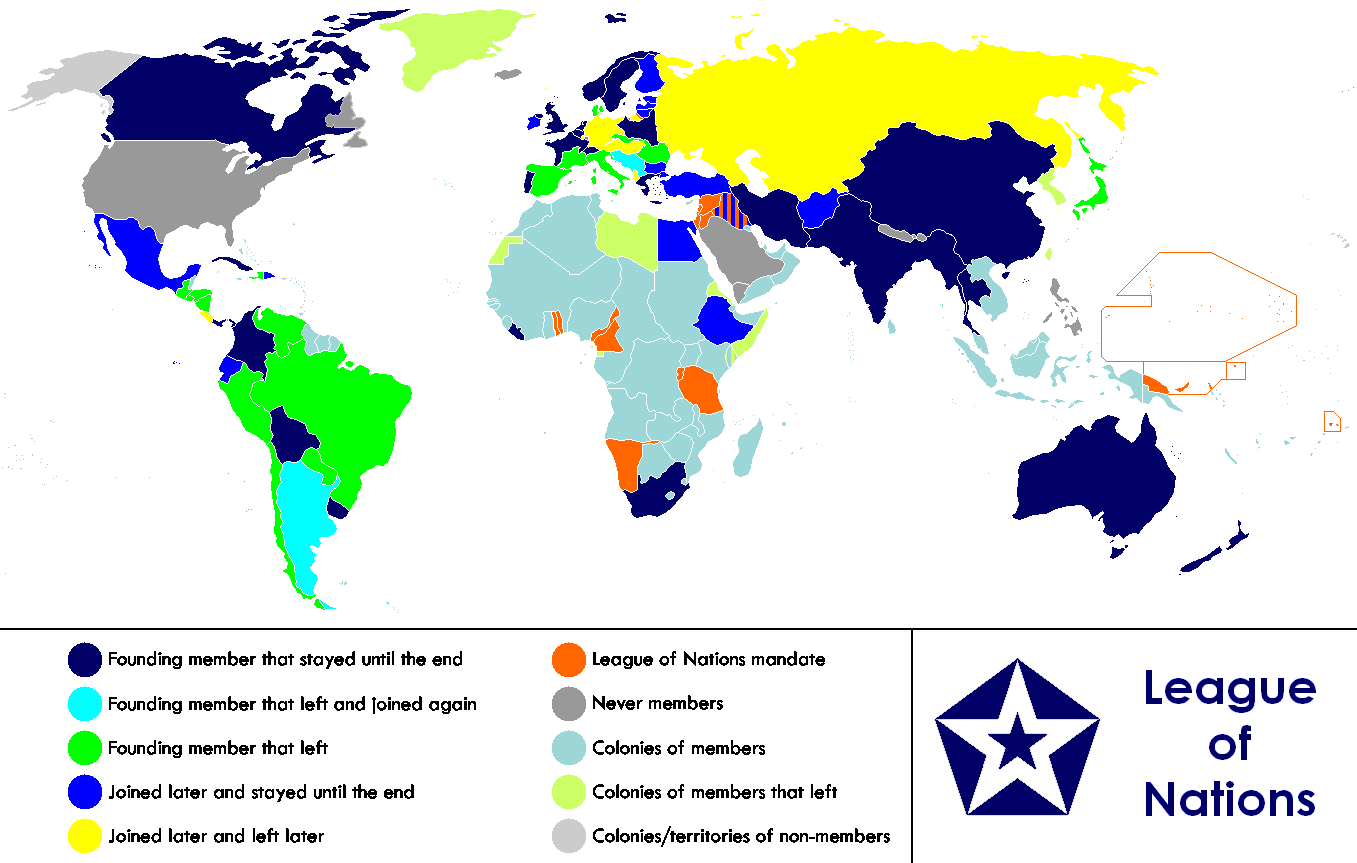
English: Anachronous map of the world between 1920 and 1945 which shows the The League of Nations and the world.
Français : Carte du monde entre 1920 et 1945 montrant la place de la Société des Nations |
| Date | |
| Source | |
| Author | Allard Postman, The Netherlands |
| Other versions |
Derivative works of this file: |
Licensing
| This file is licensed under the Creative Commons Attribution-Share Alike 3.0 Unported license. Subject to disclaimers. | ||
| ||
| This licensing tag was added to this file as part of the GFDL licensing update. |

|
Permission is granted to copy, distribute and/or modify this document under the terms of the GNU Free Documentation License, Version 1.2 or any later version published by the Free Software Foundation; with no Invariant Sections, no Front-Cover Texts, and no Back-Cover Texts. A copy of the license is included in the section entitled GNU Free Documentation License. Subject to disclaimers. |
File history
Click on a date/time to view the file as it appeared at that time.
| Date/Time | Thumbnail | Dimensions | User | Comment | |
|---|---|---|---|---|---|
| current | 23:02, 18 February 2023 | | 1,357 × 863 (39 KB) | RickoTroanman22 | Added vertical striped pattern to Jubaland to indicate that it was transferred to Italy. Removed mostly unrecognized nations (Dervish were not recognized by anyone and Tuva and Mongolia were only recognized by the USSR.) |
| 05:49, 4 November 2021 |  | 1,357 × 863 (59 KB) | Randomastwritter | jubaland | |
| 17:36, 13 July 2019 |  | 1,357 × 863 (50 KB) | Palaeozoic99 | Change Dominion of Newfoundland; colonial status ceased in 1907. Was never a member. | |
| 18:52, 29 September 2011 |  | 1,357 × 863 (47 KB) | DrKay | Restore Mongolia (which was removed based on a map of 1914 but it was independent from 1921) Swap colors of constant members and new members to match the animation gif | |
| 08:01, 28 September 2011 |  | 1,357 × 863 (46 KB) | DrKay | Put non-members in grey (standard color for non-members of an organization) Put original and constant members in same color as the logo of the organization | |
| 09:31, 14 January 2011 |  | 1,357 × 863 (55 KB) | Elmor | minor text corrections | |
| 08:47, 12 January 2011 |  | 1,357 × 863 (55 KB) | Elmor | corrected Japan-Soviet border | |
| 18:43, 9 October 2009 |  | 1,357 × 863 (200 KB) | 23prootie~commonswiki | redo | |
| 18:42, 9 October 2009 |  | 1,357 × 863 (200 KB) | 23prootie~commonswiki | redo | |
| 18:40, 9 October 2009 |  | 1,357 × 863 (184 KB) | 23prootie~commonswiki | Reverted to version as of 16:17, 16 March 2009 | |
| 18:39, 9 October 2009 |  | 800 × 509 (58 KB) | 23prootie~commonswiki | Philippines was semi-independent | |
| 18:36, 9 October 2009 |  | 800 × 509 (58 KB) | 23prootie~commonswiki | Change the philippines | |
| 16:17, 16 March 2009 |  | 1,357 × 863 (184 KB) | Andrew Hampe | Reverted to version as of 10:36, 23 January 2009; Newer versions are of worse quality | |
| 05:21, 5 February 2009 |  | 1,357 × 863 (200 KB) | 23prootie~commonswiki | ||
| 04:14, 5 February 2009 |  | 1,357 × 863 (200 KB) | 23prootie~commonswiki | ||
| 10:36, 23 January 2009 |  | 1,357 × 863 (184 KB) | Cognatus | {{retouched|fixed typos in legend... No sweat of the brow here.}} | |
| 20:28, 12 January 2009 |  | 1,357 × 863 (26 KB) | Fluteflute | transparent background and optipng | |
| 19:59, 6 September 2008 |  | 1,357 × 863 (47 KB) | Canuckguy | {{Information |Description= |Source= |Date= |Author= |Permission= |other_versions= }} | |
| 05:09, 3 September 2008 |  | 1,357 × 863 (48 KB) | PhiLiP | According to a map of Republic of China published in 1914, Tibet and Mongolia were belong to China at that time. | |
| 15:30, 23 April 2008 |  | 1,357 × 863 (45 KB) | Haukurth | Iceland was not a colony, it just wasn't a member. It chose not to join even though that League confirmed that it could. | |
| 03:33, 15 November 2007 |  | 1,357 × 863 (48 KB) | Kelvinc | Korea and Taiwan re-coloured as colony of left member (Japan) | |
| 18:05, 4 August 2007 |  | 1,357 × 863 (70 KB) | Sylfide | {{Information |Description=Anachronous map of the world between 1920-1944 which shows the The League of Nations and the world. / ''Carte du monde entre 1924 et 1944 montrant la place de la Société des Nations'' |Source=:en:Image:League_of_Nations_Anachr |
File usage
The following pages on the English Wikipedia use this file (pages on other projects are not listed):
Global file usage
The following other wikis use this file:
- Usage on af.wikipedia.org
- Usage on ast.wikipedia.org
- Usage on as.wikipedia.org
- Usage on be.wikipedia.org
- Usage on bn.wikipedia.org
- Usage on br.wikipedia.org
- Usage on cs.wikipedia.org
- Usage on diq.wikipedia.org
- Usage on es.wikipedia.org
- Usage on eu.wikipedia.org
- Usage on fa.wikipedia.org
- Usage on fi.wikipedia.org
- Usage on fy.wikipedia.org
- Usage on hr.wikipedia.org
- Usage on hy.wikipedia.org
- Usage on io.wikipedia.org
- Usage on is.wikipedia.org
- Usage on ka.wikipedia.org
- Usage on ko.wikipedia.org
- Usage on krc.wikipedia.org
- Usage on lb.wikipedia.org
- Usage on li.wikipedia.org
- Usage on ml.wikipedia.org
- Usage on my.wikipedia.org
- Usage on ne.wikipedia.org
- Usage on nl.wikipedia.org
- Usage on pa.wikipedia.org
- Usage on si.wikipedia.org
- Usage on sk.wikipedia.org
- Usage on sv.wikipedia.org
- Usage on ta.wikipedia.org
- Usage on te.wikipedia.org
- Usage on th.wikipedia.org
- Usage on zh.wikipedia.org