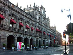
Municipal Hall of Puebla
You can help expand this article with text translated from the corresponding article in Spanish. (July 2019) Click [show] for important translation instructions.
|
| Municipal Hall of Puebla | |
|---|---|
 | |
 | |
| General information | |
| Town or city | Puebla, Puebla |
| Country | Mexico |
| Coordinates | 19°2′38″N 98°11′51″W / 19.04389°N 98.19750°W |
| Design and construction | |
| Architect(s) | Charles T. S. Hall |
The Municipal Hall of Puebla is a building in Puebla's historic centre, in the Mexican state of Puebla.
External links[edit]
 Media related to Municipal Hall of Puebla City at Wikimedia Commons
