Richat Structure: Difference between revisions
Ripchip Bot (talk | contribs) m r2.7.1) (robot Modifying: hu:Richat képződmény |
No edit summary |
||
| Line 3: | Line 3: | ||
[[Image:Richat Structure - SRTM.jpg|thumb|250px|A topographic reconstruction (scaled 6:1 on the vertical axis) from satellite photos. False coloring as follows: bedrock=brown, sand=yellow/white, vegetation=green, salty sediments=blue.]] |
[[Image:Richat Structure - SRTM.jpg|thumb|250px|A topographic reconstruction (scaled 6:1 on the vertical axis) from satellite photos. False coloring as follows: bedrock=brown, sand=yellow/white, vegetation=green, salty sediments=blue.]] |
||
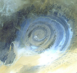
[[Image:ASTER Richat.jpg|thumb|250px|Satellite picture of the Richat Structure.]] |
[[Image:ASTER Richat.jpg|thumb|250px|Satellite picture of the Richat Structure.]] |
||
The '''Richat Structure''' is a prominent circular feature in the [[Sahara]] desert of [[Mauritania]] near [[Ouadane]]. It has attracted attention since the earliest space missions because it forms a conspicuous [[bullseye (target)|bull's-eye]] in the otherwise rather featureless expanse of the desert. The structure, which has a diameter of approx {{Convert|50|km|mi|0}} and is located {{Convert|400|-|450|m|ft|-1}} above [[sea level]], has become a landmark for [[space shuttle]] crews. |
The '''Richat Structure''', also known as the '''Eye of the Sahara''', is a prominent circular feature in the [[Sahara]] desert of [[Mauritania]] near [[Ouadane]]. It has attracted attention since the earliest space missions because it forms a conspicuous [[bullseye (target)|bull's-eye]] in the otherwise rather featureless expanse of the desert. The structure, which has a diameter of approx {{Convert|50|km|mi|0}} and is located {{Convert|400|-|450|m|ft|-1}} above [[sea level]], has become a landmark for [[space shuttle]] crews. |
||
Initially interpreted as a [[meteorite]] impact structure because of its high degree of circularity, it is now thought to be a symmetrical uplift (circular [[anticline]] or [[dome (geology)|dome]]) that has been laid bare by [[erosion]]. [[Paleozoic]] [[quartzite]]s form the resistant beds outlining the structure. The lack of shock metamorphism at the site further backs the latter claim.<ref>http://www.lpi.usra.edu/meetings/metsoc2001/pdf/5237.pdf</ref> |
Initially interpreted as a [[meteorite]] impact structure because of its high degree of circularity, it is now thought to be a symmetrical uplift (circular [[anticline]] or [[dome (geology)|dome]]) that has been laid bare by [[erosion]]. [[Paleozoic]] [[quartzite]]s form the resistant beds outlining the structure. The lack of shock metamorphism at the site further backs the latter claim.<ref>http://www.lpi.usra.edu/meetings/metsoc2001/pdf/5237.pdf</ref> |
||
Revision as of 15:07, 4 May 2011
This article needs attention from an expert in Geology. Please add a reason or a talk parameter to this template to explain the issue with the article. (October 2008) |


The Richat Structure, also known as the Eye of the Sahara, is a prominent circular feature in the Sahara desert of Mauritania near Ouadane. It has attracted attention since the earliest space missions because it forms a conspicuous bull's-eye in the otherwise rather featureless expanse of the desert. The structure, which has a diameter of approx 50 kilometres (31 mi) and is located 400–450 metres (1,310–1,480 ft) above sea level, has become a landmark for space shuttle crews.
Initially interpreted as a meteorite impact structure because of its high degree of circularity, it is now thought to be a symmetrical uplift (circular anticline or dome) that has been laid bare by erosion. Paleozoic quartzites form the resistant beds outlining the structure. The lack of shock metamorphism at the site further backs the latter claim.[1]
References
- Original entry was from the NASA Earth Observatory http://earthobservatory.nasa.gov/Newsroom/NewImages/images.php3?img_id=9319
Further reading
- Guillaume Matton, Michel Jébrak and James K.W. Lee (2005). "Resolving the Richat enigma: Doming and hydrothermal karstification above an alkaline complex". Geology. 33 (8): 665–668. doi:10.1130/G21542.1.
{{cite journal}}: Unknown parameter|month=ignored (help)
