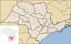
Taiaçu
Taiaçu | |
|---|---|
 Location in São Paulo state | |
| Coordinates: 21°8′40″S 48°30′45″W / 21.14444°S 48.51250°W | |
| Country | Brazil |
| Region | Southeast |
| State | São Paulo |
| Area | |
| • Total | 107 km2 (41 sq mi) |
| Population (2020 [1]) | |
| • Total | 6,320 |
| • Density | 59/km2 (150/sq mi) |
| Time zone | UTC−3 (BRT) |
Taiaçu is a municipality in the state of São Paulo in Brazil. The population is 6,320 (2020 est.) in an area of 107 km².[2] The elevation is 565 m.


