
Treasure Falls: Difference between revisions
Content deleted Content added
No edit summary |
m grammar correction |
||
| Line 13: | Line 13: | ||
| world_rank = |
| world_rank = |
||
}} |
}} |
||
'''Treasure Falls''' is a [[waterfall]] located off Hwy 160 about 15 miles northeast of [[Pagosa Springs, Colorado]]. The falls are named after a local legend of a treasure of gold on the mountain the falls plunges from. There is a trail head clearly marked off of Hwy 160. The falls are somewhat visible from the parking lot, and a short |
'''Treasure Falls''' is a [[waterfall]] located off Hwy 160 about 15 miles northeast of [[Pagosa Springs, Colorado]]. The falls are named after a local legend of a treasure of gold on the mountain the falls plunges from. There is a trail head clearly marked off of Hwy 160. The falls are somewhat visible from the parking lot, and a short and moderately steep hike of about 15 minutes and 300 feet of elevation gain will arrive hikers at the base of the falls where there is a foot bridge for excellent viewing. A switchback trail will take hikers closer to the plunge base, called the "Misty Deck" where hikers can view and feel the spray of the falls. |
||
==Images== |
==Images== |
||
Revision as of 13:43, 11 June 2013
| Treasure Falls | |
|---|---|
 The falls from the lower foot bridge | |
 | |
| Location | Mineral County, Colorado, USA |
| Coordinates | 37°26′35″N 106°52′26″W / 37.44306°N 106.87389°W[1] |
| Type | Single |
| Total height | 105 feet (32 m) |
| Number of drops | 1 |
| Longest drop | 105 feet (32 m) |
| Watercourse | Fall Creek |
Treasure Falls is a waterfall located off Hwy 160 about 15 miles northeast of Pagosa Springs, Colorado. The falls are named after a local legend of a treasure of gold on the mountain the falls plunges from. There is a trail head clearly marked off of Hwy 160. The falls are somewhat visible from the parking lot, and a short and moderately steep hike of about 15 minutes and 300 feet of elevation gain will arrive hikers at the base of the falls where there is a foot bridge for excellent viewing. A switchback trail will take hikers closer to the plunge base, called the "Misty Deck" where hikers can view and feel the spray of the falls.
Images
-
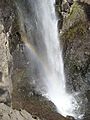 A Rainbow formed in the plunge mist
