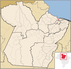
Vigia, Pará
Vigia | |
|---|---|
Municipality | |
 Location in Pará state | |
| Coordinates: 0°51′30″S 48°8′30″W / 0.85833°S 48.14167°W | |
| Country | |
| State | Pará |
| Area | |
| • Total | 539.08 km2 (208.14 sq mi) |
| Population (2020 [1]) | |
| • Total | 54,172 |
| • Density | 100/km2 (260/sq mi) |
| Time zone | UTC-3 (BRT) |
Vigia is a municipality in the northeastern part of the state of Pará, Brazil. The town was founded on 16 January 1616. The population is 54,172 (2020 est.) in an area of 539.08 km².[2]
Population history
| Year | Population |
|---|---|
| 2004 | 41,637 |
| 2006 | 42,214 |
| 2015 | 51,173 |
| 2020 | 54,172 |
References
External links
- https://web.archive.org/web/20070203101758/http://www.citybrazil.com.br/pi/stoantoniomilagres/ (in Portuguese)
- Municipal anthem of Vigia (in Portuguese)

