Saussay, Eure-et-Loir
Saussay | |
|---|---|
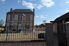
 The town hall in Saussay | |
| Coordinates: 48°51′35″N 1°24′49″E / 48.8596°N 1.4135°E | |
| Country | France |
| Region | Centre-Val de Loire |
| Department | Eure-et-Loir |
| Arrondissement | Dreux |
| Canton | Anet |
| Intercommunality | CA du Pays de Dreux |
| Government | |
| • Mayor (2014–2020) | Patrick Gourdes |
| Area 1 | 4.59 km2 (1.77 sq mi) |
| Population (2021)[1] | 1,099 |
| • Density | 240/km2 (620/sq mi) |
| Time zone | UTC+01:00 (CET) |
| • Summer (DST) | UTC+02:00 (CEST) |
| INSEE/Postal code | 28371 /28260 |
| Elevation | 60–122 m (197–400 ft) (avg. 60 m or 200 ft) |
| 1 French Land Register data, which excludes lakes, ponds, glaciers > 1 km2 (0.386 sq mi or 247 acres) and river estuaries. | |
Saussay is a commune in the Eure-et-Loir department and Centre-Val de Loire region of north-central France. It lies 47 km north of Chartres and some 70 km west of Paris.
Population
| Year | 1946 | 1954 | 1962 | 1968 | 1975 | 1982 | 1990 | 1999 | 2007 | 2015 |
|---|---|---|---|---|---|---|---|---|---|---|
| Population | 423 | 401 | 400 | 463 | 601 | 650 | 900 | 981 | 1053 | 1075 |
See also
References
- ^ "Populations légales 2021". The National Institute of Statistics and Economic Studies. 28 December 2023.
Wikimedia Commons has media related to Saussay (Eure-et-Loir).


