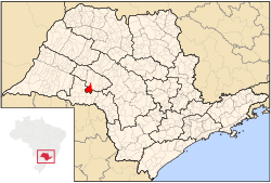
Echaporã
Appearance
Echaporã | |
|---|---|
 Location in São Paulo state | |
| Coordinates: 22°25′46″S 50°12′2″W / 22.42944°S 50.20056°W | |
| Country | Brazil |
| Region | Southeast |
| State | São Paulo |
| Area | |
| • Total | 516 km2 (199 sq mi) |
| Population (2020 [1]) | |
| • Total | 6,064 |
| • Density | 12/km2 (30/sq mi) |
| Time zone | UTC-03:00 (BRT) |
| • Summer (DST) | UTC-02:00 (BRST) |
Echaporã is a municipality in the state of São Paulo in Brazil. The population is 6,064 (2020 est.) in an area of 516 km².[2] The elevation is 700 m.
References


