Shelter Island (Alaska)
Appearance
 North end of Shelter Island (2011) | |
| Geography | |
|---|---|
| Coordinates | 58°25′00″N 134°51′15″W / 58.41667°N 134.85417°W |
| Archipelago | Alexander Archipelago |
| Administration | |
United States | |
| State | Alaska |
Shelter Island is an island in the Alexander Archipelago, southeast of Lincoln Island and northwest of Juneau, Alaska, U.S. It trends northwest between Favorite and Saginaw channels. It was named in 1869 by Commander R. W. Meade of the United States Navy.[1] The first European to sight the island was Joseph Whidbey, master of HMS Discovery during George Vancouver's 1791–95 expedition, in 1794.[2]
Gallery
[edit]-
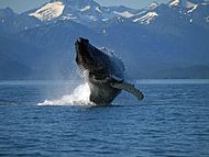
Humpback whale breaching just off South Shelter Island
References
[edit]- ^ U.S. Geological Survey Geographic Names Information System: Shelter Island
- ^ Vancouver, George, and John Vancouver (1801). A voyage of discovery to the North Pacific ocean, and round the world. London: J. Stockdale.
{{cite book}}: CS1 maint: multiple names: authors list (link)


