Itz
Appearance
| Itz | |
|---|---|
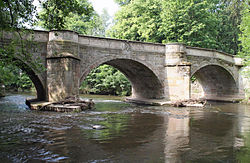
 The Jews' Bridge (Template:Lang-de) crosses the Itz in Coburg | |
 | |
| Location | |
| Country | Germany |
| States | |
| Physical characteristics | |
| Source | |
| • location | in the Thuringian Forest near Sachsenbrunn |
| • elevation | 673 m (2,208 ft) |
| Mouth | |
• location | Main southeast of Baunach |
• coordinates | 49°58′59″N 10°52′5″E / 49.98306°N 10.86806°E |
• elevation | 259 m (850 ft) |
| Length | 79.1 km (49.2 mi) [1] |
| Basin size | 1,031 km2 (398 sq mi) [1] |
| Discharge | |
| • average | 9.29 m3/s (328 cu ft/s) |
| Basin features | |
| Progression | Main→ Rhine→ North Sea |
The Itz is a river of Thuringia and Bavaria, Germany.
The Itz is 79-kilometre (49 mi) long and a right tributary of the Main.
The Itz begins in Sachsenbrunn (Stelzen), Thuringia and flows southward through Bachfeld and Schalkau. It crosses into Bavaria and feeds the Froschgrundsee reservoir. It continues through Dörfles-Esbach, Coburg, and Großheirath, then is joined by the Rodach north of Itzgrund. It continues southward to Rattelsdorf and Baunach, where it joins the Main.
The Itz flooded Coburg in early 2003.[2]
See also
References
- ^ a b Complete table of the Bavarian Waterbody Register by the Bavarian State Office for the Environment (xls, 10.3 MB)
- ^ "Winds, Rains Pound Europe; 6 Killed". Los Angeles Times. January 4, 2003. p. A-7. Retrieved 2008-11-16.
