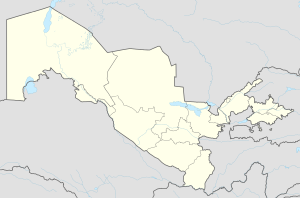
Urgut District
Urgut District | |
|---|---|
 View from Takhta-Karacha Pass (M39) to the north | |
| Coordinates: 39°24′N 67°15′E / 39.400°N 67.250°E | |
| Country | |
| Region | Samarqand Region |
| Capital | Urgut |
| Elevation | 1,000 m (3,280.84 ft) |
| Time zone | UTC+5 (UZT) |
Urgut District is a district of Samarqand Region in Uzbekistan. The capital lies at Urgut. It is located on the northern slope of the Zarafshan Range.[1] There is a Navrouz festival every spring equinox.[2]
Economy
The district produces tobacco[3] and wool and silk products.[4] Urgut town has market days every weekend, and is one of the largest market towns in the region. The district is home to carpets, jewels, metalwork and ceramics. The market also has smithies, tin workshops and stalls selling locally produced tea sets, clothes and traditional leather boots.[1]
Notes
- ^ a b "Urgut Uzbekistan :: History, monuments and pictures of Urgut. Weather in Urgut. Urgut picture". Orexca.com. Retrieved 2014-02-14.
- ^ "Urgut, near the town of Samarkand. "Navrouz" Festival (spring equinox) held in the hills. (PAR24336)". Highbeam.com. Archived from the original on 2012-11-02. Retrieved 2014-02-14.
- ^ ""Бритиш Американ Тобакко" Ургутский Филиал, табак ферментированный" ("British-American Tobacco Company, Urgut branch, cured tobacco"), in Russian, accessed 6 June 2009
- ^ "Uzbekistan: Searching the Heart of Central Asia", accessed 16 January 2008, from Internet Archive
External links
- "Гео каталог / Ургутский район" ("Geo Catalog - Urgut District"), photographs of Urgut District, in Russian


