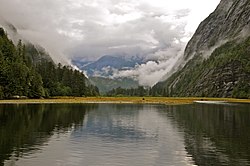
Mussel Inlet
Appearance

Mussel Inlet is in inlet in the North Coast region of the Canadian province of British Columbia. It is a northeast extension of Sheep Passage,[1] and part of the Fiordland Conservancy.
Name origin and history
It was first charted in 1793 by James Johnstone, one of George Vancouver's officers during his 1791-95 expedition. It was here the men ate mussels that poisoned and killed one of them, John Carter, for whom Carter Bay is named; it is at the junction of Finlayson Channel and the west end of Sheep Passage at 52°49′33″N 128°23′46″W / 52.82583°N 128.39611°W.[2] Poison Cove at 52°54′21″N 128°02′00″W / 52.90583°N 128.03333°W[3] being the location where the mussels were harvested.[4] A creek northwest into that cove is Poison Cove Creek.[5][6]
References
- ^ "Mussel Inlet". BC Geographical Names.
- ^ BC Names/GeoBC entry "Carter Bay"
- ^ BC Names/GeoBC entry "Poison Cove"
- ^ BC Names/GeoBC entry "Poison Cove"
- ^ BC Names/GeoBC entry "Poison Cove Creek"
- ^ Vancouver, George, and John Vancouver (1801). A voyage of discovery to the North Pacific ocean, and round the world. London: J. Stockdale.
{{cite book}}: CS1 maint: multiple names: authors list (link)
