Jump to content

County of Banks, Queensland

Coordinates: 15°23′S 144°52′E / 15.383°S 144.867°E / -15.383; 144.867
From Wikipedia, the free encyclopedia

This is the current revision of this page, as edited by 60.241.9.110 (talk) at 08:12, 4 December 2021. The present address (URL) is a permanent link to this version.

(diff) ← Previous revision | Latest revision (diff) | Newer revision → (diff)

Banks
Queensland
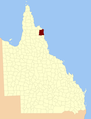
Location within Queensland
Lands administrative divisions around Banks:
Melville Melville
Mosman Banks Coral Sea
Chelmsford Dagmar Solander

The county of Banks is one of the counties of Queensland, Australia, that existed before 1901.[1] The county is divided into civil parishes. It is located in Far North Queensland, and is named for Sir Joseph Banks, who with Captain James Cook landed in 1770 at a location within the county. Banks includes the towns of Cooktown, Lakeland and Laura.[2]

Parishes

[edit]
Parish LGA Coordinates Notes
Annan Cook 15°35′S 145°15′E / 15.583°S 145.250°E / -15.583; 145.250 (Annan Parish)
Battle Camp Cook 15°22′S 144°39′E / 15.367°S 144.650°E / -15.367; 144.650 (Battle Camp Parish)
Bullhead Cook 15°50′S 144°49′E / 15.833°S 144.817°E / -15.833; 144.817 (Bullhead Parish) Lakeland
Cahir Cook 15°12′S 144°39′E / 15.200°S 144.650°E / -15.200; 144.650 (Cahir Parish)
Cook Cook 15°30′S 145°14′E / 15.500°S 145.233°E / -15.500; 145.233 (Cook Parish) Cooktown
Cowton Cook 14°59′S 144°52′E / 14.983°S 144.867°E / -14.983; 144.867 (Cowton Parish)
Deighton Cook 15°30′S 144°33′E / 15.500°S 144.550°E / -15.500; 144.550 (Deighton Parish) Laura
Discovery Hope Vale (A) 15°13′S 145°11′E / 15.217°S 145.183°E / -15.217; 145.183 (Discovery Parish)
Emla Cook 15°20′S 144°31′E / 15.333°S 144.517°E / -15.333; 144.517 (Emla Parish)
Endeavour Hope Vale (A) 15°21′S 145°15′E / 15.350°S 145.250°E / -15.350; 145.250 (Endeavour Parish)
Flattery Hope Vale (A) 14°54′S 145°11′E / 14.900°S 145.183°E / -14.900; 145.183 (Flattery Parish)
Gore Cook 15°52′S 145°04′E / 15.867°S 145.067°E / -15.867; 145.067 (Gore Parish)
Green Cook 15°32′S 144°56′E / 15.533°S 144.933°E / -15.533; 144.933 (Green Parish)
Gresley Cook 15°47′S 144°30′E / 15.783°S 144.500°E / -15.783; 144.500 (Gresley Parish)
Hann Hope Vale (A) 15°20′S 145°07′E / 15.333°S 145.117°E / -15.333; 145.117 (Hann Parish) Hope Vale
Hicks Cook 15°34′S 145°05′E / 15.567°S 145.083°E / -15.567; 145.083 (Hicks Parish)
Lythe Cook 14°57′S 144°40′E / 14.950°S 144.667°E / -14.950; 144.667 (Lythe Parish)
Macquarie Cook 15°39′S 144°34′E / 15.650°S 144.567°E / -15.650; 144.567 (Macquarie Parish)
McIvor Cook 15°07′S 145°03′E / 15.117°S 145.050°E / -15.117; 145.050 (McIvor Parish)
Melsonby Cook 15°07′S 144°51′E / 15.117°S 144.850°E / -15.117; 144.850 (Melsonby Parish)
Monkhouse Cook 15°45′S 145°17′E / 15.750°S 145.283°E / -15.750; 145.283 (Monkhouse Parish)
Munburra Cook 14°53′S 145°04′E / 14.883°S 145.067°E / -14.883; 145.067 (Munburra Parish)
Ninda Cook 15°38′S 144°46′E / 15.633°S 144.767°E / -15.633; 144.767 (Ninda Parish)
Pickersgill Cook 15°18′S 144°56′E / 15.300°S 144.933°E / -15.300; 144.933 (Pickersgill Parish)
Pryde Cook 15°10′S 145°01′E / 15.167°S 145.017°E / -15.167; 145.017 (Pryde Parish)
Ruby Cook 15°29′S 144°47′E / 15.483°S 144.783°E / -15.483; 144.783 (Ruby Parish)
Saunders Cook 15°39′S 144°54′E / 15.650°S 144.900°E / -15.650; 144.900 (Saunders Parish)
Solander Cook 15°27′S 145°06′E / 15.450°S 145.100°E / -15.450; 145.100 (Solander Parish)
Tayeto Hope Vale (A) 15°03′S 145°12′E / 15.050°S 145.200°E / -15.050; 145.200 (Tayeto Parish)
Tupia Cook 15°02′S 145°03′E / 15.033°S 145.050°E / -15.033; 145.050 (Tupia Parish)
Welbury Cook 15°06′S 144°39′E / 15.100°S 144.650°E / -15.100; 144.650 (Welbury Parish)
Yarico Cook 15°18′S 144°48′E / 15.300°S 144.800°E / -15.300; 144.800 (Yarico Parish)

References

[edit]

15°23′S 144°52′E / 15.383°S 144.867°E / -15.383; 144.867