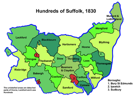
Stow Hundred
Appearance
Stow was a hundred of Suffolk, consisting of 22,710 acres (91.9 km2).[1]
Stow Hundred a fertile and picturesque district in central Suffolk around seven miles (11 km) in length and breadth. It is bounded by Cosford, Bosmere and Claydon, Thedwestry, Blackbourn and Hartismere Hundreds. It is in the Deanery to which it gives name and was in the Archdeaconry of Sudbury until 1837 when it was added to the Archdeaconry of Suffolk, and is thus still in the Diocese of Norwich. It is watered by the River Gipping.
The word "stow" means place, as in "stow away", and the name of the hundred was probably derived from an old name for Stowmarket, the hundred's largest town.[2]
Parishes
[edit]
Stow Hundred consisted of the following 14 parishes:[1][3]
| Parish | Area (acres) |
|---|---|
| Buxhall | 2524 |
| Combs | 3000 |
| Creeting St Peter | 1336 |
| Gipping | 900 |
| Great Finborough | 1632 |
| Harleston | 620 |
| Haughley | 2700 |
| Little Finborough | 360 |
| Old Newton | 2349 |
| Onehouse | 866 |
| Shelland | 509 |
| Stowmarket | 1240 |
| Stowupland | 2890 |
| Wetherden | 1784 |
References
[edit]- ^ a b William White (1844). History, gazetteer, and directory of Suffolk. p. 265.
- ^ Walter Skeat (1913). The Place-names of Suffolk.
- ^ 1841 Census

