Lutton, Northamptonshire
Appearance
| Lutton | |
|---|---|
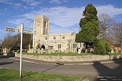
 St Peter's parish church | |
Location within Northamptonshire | |
| Population | 186 (2011 Census) |
| OS grid reference | TL1187 |
| Civil parish |
|
| Unitary authority | |
| Ceremonial county | |
| Region | |
| Country | England |
| Sovereign state | United Kingdom |
| Post town | Peterborough |
| Postcode district | PE8 |
| Dialling code | 01832 |
| Police | Northamptonshire |
| Fire | Northamptonshire |
| Ambulance | East Midlands |
| UK Parliament | |
Lutton is a village and civil parish in North Northamptonshire, England. The 2011 Census recorded its parish population as 186.[1]
The villages name means 'Farm/settlement connected with Luda' or perhaps, 'farm/settlement on Hluding (= the loud one)', an old name for what is now called Billing Brook.[2]
The oldest parts of the Church of England parish church of St Peter are 12th-century. North and south aisles and arcades were added to the nave in the 13th century. The church is a Grade I listed building.[3]
References
- ^ "Area: Lutton (Parish): Key Figures for 2011 Census: Key Statistics". Neighbourhood Statistics. Office for National Statistics. Retrieved 6 November 2015.
- ^ "Key to English Place-names".
- ^ Historic England. "Church of St Peter (Grade I) (1040231)". National Heritage List for England. Retrieved 6 November 2015.
Further reading
- Pevsner, Nikolaus; Cherry, Bridget (revision) (1973) [1961]. Northamptonshire. The Buildings of England (2nd ed.). Harmondsworth: Penguin Books. p. 299. ISBN 0-14-071022-1.
- RCHME, ed. (1975). "Lutton". An Inventory of the Historical Monuments in the County of Northamptonshire. Vol. 1, Archaeological Sites in North-East Northamptonshire. London: Royal Commission on the Historical Monuments of England. pp. 65–67.
- RCHME, ed. (1984). "Lutton". An Inventory of the Historical Monuments in the County of Northamptonshire. Vol. 6, Architectural Monuments in North Northamptonshire. London: Royal Commission on the Historical Monuments of England.
External links
Wikimedia Commons has media related to Lutton, Northamptonshire.

