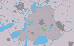
Ouwsterhaule
Ouwsterhaule
Ousterhaule | |
|---|---|
Village | |
 Ouwsterhaule church | |
 Location in the former Skarsterlân municipality | |
| Coordinates: 52°56′16″N 5°48′48″E / 52.93778°N 5.81333°E | |
| Country | |
| Province | |
| Municipality | |
| Area | |
| • Total | 2.03 km2 (0.78 sq mi) |
| Elevation | −0.7 m (−2.3 ft) |
| Population (2021)[1] | |
| • Total | 85 |
| • Density | 42/km2 (110/sq mi) |
| Postal code | 8513[1] |
| Dialing code | 0513 |
Ouwsterhaule (Template:Lang-fry) is a village in De Fryske Marren municipality in the province of Friesland, the Netherlands. It had a population of around 355 in 2017.[3]
History
The village was first mentioned in the 13th century as Haula. Ouwster is a reference to the Ouwer region.[4] The etymology of haule is unclear.[5] There used to be three churches in the Ouwer region. In 1730, the church of Ouwsterhaule was the only one remaining due to the construction of roads. The church has 14th century elements. In 1840, it was home to 82 people. There is a public transport museum in the village with buses, a rail transport modelling and wooden trains sets for the children.[6]
Before 2014, Ouwsterhaule was part of the Skarsterlân municipality and before 1984 it was part of Doniawerstal.[6]

References
- ^ a b c "Kerncijfers wijken en buurten 2021". Central Bureau of Statistics. Retrieved 29 March 2022.
- ^ "Postcodetool for 8513CA". Actueel Hoogtebestand Nederland (in Dutch). Het Waterschapshuis. Retrieved 29 March 2022.
- ^ Kerncijfers wijken en buurten 2017 - CBS
- ^ "Ouwsterhaule - (geografische naam)". Etymologiebank (in Dutch). Retrieved 29 March 2022.
- ^ "Haule - (geografische naam)". Etymologiebank (in Dutch). Retrieved 29 March 2022.
- ^ a b "Ouwsterhaule". Plaatsengids (in Dutch). Retrieved 29 March 2022.
External links
![]() Media related to Ouwsterhaule at Wikimedia Commons
Media related to Ouwsterhaule at Wikimedia Commons


