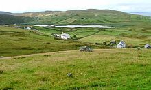
Clashmore, Assynt
Appearance

Clashmore (Scottish Gaelic: An Clais Mór[1]) is a scattered township in Assynt, in Sutherland, in the Highland council area of Scotland. It is situated on the Rubha Stoer, 10 km north west of Lochinver, overlooking the Loch na Claise.
References
- The geographic coordinates are from the Ordnance Survey.
- ^ Iain Mac an Tàilleir (2003). "Placenames collected by Iain Mac an Tailleir". Scottish Parliament. Archived from the original on 25 December 2010. Retrieved 29 January 2011.
58°13′27″N 5°20′54″W / 58.22417°N 5.34833°W
