
Crap Mats
| Crap Mats | |
|---|---|
 Crap Mats, view from Fürstenau | |
| Highest point | |
| Elevation | 2,947 m (9,669 ft)[1] |
| Prominence | 97 m (318 ft)[2] |
| Parent peak | Ringelspitz |
| Coordinates | 46°52′41.7″N 9°21′26.4″E / 46.878250°N 9.357333°E |
| Geography | |
 Crap Mats Location in Switzerland | |
| Location | Graubünden, Switzerland |
| Parent range | Glarus Alps |
The Crap Mats is a mountain of the Glarus Alps, overlooking the Rhine valley near Bonaduz in the canton of Graubünden. It lies just south of the Ringelspitz.
-
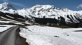 The Crap Mats (far left) and the Ringelspitz from the Kunkels Pass

References
[edit]- ^ Retrieved from the Swisstopo topographic maps
- ^ Retrieved from Google Earth
External links
[edit]
This Graubünden location article is a stub. You can help Wikipedia by expanding it. |