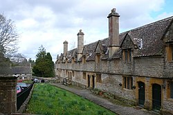
Helyar Almshouses
Appearance
| Helyar Almshouses | |
|---|---|
 | |
| Location | East Coker, Somerset, England |
| Coordinates | 50°54′30.93″N 2°39′23.32″W / 50.9085917°N 2.6564778°W |
| Built | 1640-1660 |
| Built for | Archdeacon Helyar |
| Restored | 19th century |
Listed Building – Grade II | |
| Official name | Helyar Almshouses |
| Designated | 19 April 1961[1] |
| Reference no. | 263662 |
The Helyar Almshouses were erected between 1640[1] and 1660 by William Helyar Archdeacon of Barnstable of Coker Court, East Coker, Somerset, England.
The building work was interrupted by the plague of 1645, and the English Civil War and the almshouses were not completed until 1660, by which time, the Archdeacon was dead, and the work was completed by his grandson (also William Helyar).
In 1868 the almshouses had an income of £46 per annum[2] (equivalent to £5,228 in 2023).[3] It still operates a charity and had an income of £9,313 in 2005.[4]
References
- ^ a b "Helyar Almshouses". historicengland.org.uk. English Heritage. Retrieved 19 October 2011.
- ^ The National Gazetteer of Great Britain and Ireland (1868)
- ^ UK Retail Price Index inflation figures are based on data from Clark, Gregory (2017). "The Annual RPI and Average Earnings for Britain, 1209 to Present (New Series)". MeasuringWorth. Retrieved 7 May 2024.
- ^ "245432 - HELYAR'S ALMSHOUSES". Charity Commission. Retrieved 19 October 2011.
External links
Wikimedia Commons has media related to Helyar Almshouses.

