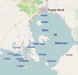
Calbuco Archipelago
Appearance
Native name: Archipiélago de Calbuco | |
|---|---|
 | |
 | |
| Geography | |
| Coordinates | 41°48′S 73°02′W / 41.800°S 73.033°W |
| Adjacent to | Reloncaví Sound |
| Administration | |
| Region | Los Lagos |
| Province | Llanquihue |
| Commune | Calbuco |
| Additional information | |
| NGA UFI -874659 (only Calbuco Island) | |
Calbuco Archipelago is located in the Reloncaví Sound, Llanquihue Province, Los Lagos Region, Chile.
The archipelago is composed of 14 islands.
List of islands
The islands are:[1]
- Puluqui
- Caicué / Lagartija
- Queulín
- Chaullín / Helvecia (not to be confused with Chaullin Island (Chiloe))
- Huar / Guar
- Abtao
- Chidhuapi
- Quenu
- Quihua
- Tautil
- Calbuco / Caicaén
- Tabón
- Mayelhue
- Lín
The last three islands, Tabon, Mayelhue and Lin, are by low tide only one island.
References
- ^ "Plan Regulador Comunal de Calbuco". Archived from the original on 2016-04-11. Retrieved 2018-11-09.
External links
