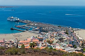
Port of Los Cristianos
Appearance
| Port of Los Cristianos | |
|---|---|
 Port of Los Cristianos | |
 Click on the map for a fullscreen view | |
| Location | |
| Location | Spain |
| Coordinates | 28°2′55.00″N 16°43′9.01″W / 28.0486111°N 16.7191694°W |
The Port of Los Cristianos is a port of the Atlantic Ocean located in the town of Los Cristianos, in the municipality of Arona on the island of Tenerife (Canary Islands, Spain). It is administered by the Port Authority of Santa Cruz de Tenerife. It is the port with the highest passenger and vehicle traffic in the Canary Islands, in 2007 it had 1,829,579 passengers, and 238,836 vehicles.
The port area of Los Cristianos also occupies the first place in Spain[1] in terms of passenger traffic thanks to its links with the ports of San Sebastián de La Gomera, La Estaca in El Hierro and Santa Cruz de La Palma.
References
[edit]- ^ "Información de la Autoridad Portuaria de Santa Cruz de Tenerife". Archived from the original on 2019-09-12. Retrieved 2018-08-02.
External links
[edit]Wikimedia Commons has media related to Puerto de Los Cristianos.
- Official website (in English and Spanish)
- Puertos del Estado (in English and Spanish)
