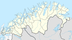
Tverrelvdalen
Appearance
Tverrelvdalen (Norwegian)
Fallijoki (Kven) | |
|---|---|
Village | |
Location in Finnmark | |
| Coordinates: 69°56′41″N 23°23′30″E / 69.94472°N 23.39167°E | |
| Country | Norway |
| Region | Northern Norway |
| County | Troms og Finnmark |
| District | Vest-Finnmark |
| Municipality | Alta Municipality |
| Area | |
| • Total | 0.4 km2 (0.2 sq mi) |
| Elevation | 103 m (338 ft) |
| Population (2017)[1] | |
| • Total | 430 |
| • Density | 1,075/km2 (2,780/sq mi) |
| Time zone | UTC+01:00 (CET) |
| • Summer (DST) | UTC+02:00 (CEST) |
| Post Code | 9517 Alta |
Tverrelvdalen (Norwegian) or Fallijoki (Kven) is a village area in the Tverrelvdalen valley in Alta Municipality in Troms og Finnmark county, Norway. It is a suburb to the southeast of the town of Alta. The river Tverrelva runs through the valley and village area. The 0.4-square-kilometre (99-acre) village has a population (2017) of 430 which gives the village a population density of 1,075 inhabitants per square kilometre (2,780/sq mi).[1] The Tverrelvdalen IL sports club is based here.[3]
References
- ^ a b c Statistisk sentralbyrå (1 January 2017). "Urban settlements. Population and area, by municipality".
- ^ "Tverrelvdalen, Alta" (in Norwegian). yr.no. Retrieved 2013-01-18.
- ^ Store norske leksikon. "Tverrelvdalen i Alta" (in Norwegian). Retrieved 2013-01-21.


