Clapper gates

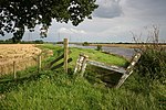
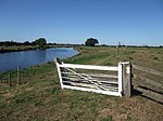
Clapper Gates are a distinctive type of self-closing double gate, unique to the navigable reaches of the River Trent.[1] They were erected along the towpath of the river in the 18th century, and allow people and horses to pass through the field boundaries on the river bank, but prevent livestock from straying.[2]
History
A horse towing path (or haling path) along the navigable Trent, from Shardlow to Gainsborough was approved as part an Act of Parliament in 1783.[3][4] But unlike canal towing paths, towpaths along rivers were not usually fenced off from the land alongside and required these self-closing gates where the path crossed the field boundaries.[5]
Construction

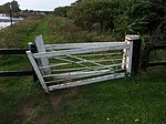
Always painted white, the normal construction is of square timber rails, with three horizontal metal rods, and a single diagonal bracing rod. The design of the gate also includes an angled upright or stile, with the post on which the gates are parked, angled in the same way.
The two gates are hinged at the top and base using a metal band attached to a large post. This heel post is inclined slightly forward, which ensures that the gates are self-closing by their own weight.[6]
The name comes from the fact that once released after opening, the gate comes together with its gate post making a sharp sound or 'clap' as it shuts. This is unlike a kissing gate, which only 'kisses' or lightly touches its frame.[7]
Heritage
They are seen as a key heritage feature of the River Trent bankside landscape, and efforts are being made to record and preserve them, in the Trent Valley between Farndon in Nottinghamshire and Gainsborough in Lincolnshire.[8][9][10] [11]
The Trent Valley Way, a long distance footpath which follows the Trentside tow path for some of its length, passes through many of these gates on its route between Nottingham and Gainsborough. [12]
Gallery
References
- De Salis, Henry Rodolph (1969). Bradshaw's Canals and Navigable Rivers. David and Charles. ISBN 0-7153-4689-X.
- Hadfield, Charles (1970). The Canals of the East Midlands. David and Charles. ISBN 0-7153-4871-X.
- ^ Fisher, Stuart (2013). British River Navigations: Inland Cuts, Fens, Dikes, Channels and Non-tidal Rivers. A&C Black. p. 70. ISBN 9781472906687.
- ^ "OnTrent Newsletter Issue Summer 2010" (PDF). ontrent.org.uk. Archived from the original (PDF) on 24 December 2013. Retrieved 10 May 2013.
- ^ Hadfield 1970, pp. 42–46
- ^ The Statutes at Large Volume 14. 1786. pp. 339–340.
- ^ De Salis 1969, pp. 3
- ^ "Riverside gate description". geograph.co.uk. Retrieved 10 May 2013.
- ^ "Torksey-Lock-Trail" (PDF). canalrivertrust.org.uk. Archived from the original (PDF) on 16 January 2014. Retrieved 10 June 2013.
- ^ "Record and reclaim clapper gates". timebank.org.uk. Archived from the original on 6 June 2014. Retrieved 19 June 2013.
- ^ "British Waterways record and reclaim clapper gates". bcvs.co.uk. Retrieved 10 May 2013.[permanent dead link]
- ^ "New Logo Trent Vale". thisisnottingham.co.uk. Retrieved 10 May 2013.[permanent dead link]
- ^ "Community Archaeology at Farndon". trentvale.co.uk. Retrieved 10 May 2013.
- ^ "Trent Valley Way". Trent Vale. trentvale.co.uk. Retrieved 10 December 2013.


