Darmsden
Appearance
| Darmsden | |
|---|---|
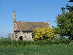
 St Andrew's Church | |
Location within Suffolk | |
| OS grid reference | TM0953 |
| Civil parish |
|
| District | |
| Shire county | |
| Region | |
| Country | England |
| Sovereign state | United Kingdom |
| Post town | IPSWICH |
| Postcode district | IP6 |
| Police | Suffolk |
| Fire | Suffolk |
| Ambulance | East of England |
Darmsden is a hamlet and civil parish in the Mid Suffolk district of Suffolk, England. Located near the A14 road around 2 kilometres (1 mi) south of the town of Needham Market, it became a civil parish in April 2013 after separating from Barking.[1][2]
The hamlet is on a private estate and has no public roads, although the main estate road linked to the B1113 is open to all.[3]
References
- ^ Darmsden: Hamlet becomes second smallest parish in mid Suffolk East Anglian Daily Times, 27 December 2012
- ^ "The Mid Suffolk District Council (Reorganisation of Community Governance) (Darmsden) Order 2012" (PDF). Local Government Boundary Commission for England. Retrieved 25 January 2020.
- ^ St Andrew, Darmsden Suffolk Churches
External links
![]() Media related to Darmsden at Wikimedia Commons
Media related to Darmsden at Wikimedia Commons

