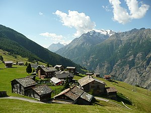
Gspon
This article's "General information" section contains promotional content. (February 2022) |

Gspon is a village in the Swiss Alps, located in the canton of Valais. The village is situated in the eastern part of the canton in the Saastal valley above Staldenried at a height of 1,893 metres (6,211 ft). It belongs to the latter municipality.
Accessible by cable car from Stalden via Staldenried, Gspon is a car-free village and a year-round tourist destination. In winter Gspon's small ski area is open.
Attractions
The village, characterised by its large green valleys and hills, is located in the Alps and is popular with hikers. Hiking is considered one of the village's main attractions along with other mountain-related activities. Gspon, which has a population of 585, also has a hotel, restaurant and bar.[1] Cable cars link to other locations above and under Gspon from the village itself.
The altitude of Gspon's football pitch is the highest in Europe at almost 2 kilometres (1.2 mi) above sea level.[2]
Highlights and facts

- Highest still operating irrigation channels in Switzerland.
- Highest football stadium in Europe, the Ottmar Hitzfeld Stadium.[3]
- Hiking and climbing routes for all ability levels.
- Snowshoe trekking in winter.
- St. Anna Chapel, built in 1691.
General information[4]

At an altitude of 1,899 metres (6,230 ft) the traffic-free village of Gspon is a starting point for both leisurely and challenging hikes. With no road into the village, access is only by cableway from Stalden via Staldenried. The village is the location of the St. Anna Chapel, built in 1691. The highest irrigation channels that are still in operation are located here, while two ski lifts are open during the winter for downhill skiers. The landscape can also be explored on snowshoes during winter.
The Bischofwäg, leading from Staldenried through pine forest and the Breiterbach Gorge to Visperterminen, was the path along which the bishop of Sion travelled. Visperterminen has the highest vineyard in Europe on a sheltered slope at an altitude of 1,150 metres (3,770 ft). A green sign-posted viniculture theme path starts at Visp railway station. The Suonen hiking trail circuit to Finileri runs through forests and alpine pastures and alongside the historic irrigation channels. A more challenging trail leads from Gspon via the Gebidum and Bistinen Passes to the Simplon Pass.
References
- Swisstopo topographic maps
- mySwitzerland.com[1]
- ^ "Spiel in den Schweizer Alpen Fußball auf höchstem Niveau". www.nike.com (in German). Retrieved 5 May 2022.
- ^ "The Beautiful Game Has a Beautiful View at Europe's Highest Pitch". Wired. Retrieved 19 May 2014.
- ^ "Ottmar Hitzfeld Stadium: What's it like to play at Europe's 'highest' football stadium?". BBC Sport. 13 October 2019.
- ^ "Gspon - Schweiz Mobil - Wanderland". Archived from the original on 19 May 2014. Retrieved 19 May 2014.
External links
![]() Media related to Gspon at Wikimedia Commons
Media related to Gspon at Wikimedia Commons
