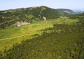
Mokra Gora (mountain)
Appearance
| Mokra Gora | |
|---|---|
| Мокра Гора | |
 | |
| Highest point | |
| Elevation | 2,156 m (7,073 ft)[1] |
| Coordinates | 42°49′56″N 20°21′49″E / 42.83222°N 20.36361°E |
| Geography | |
| Location | Serbia, Kosovo, Montenegro |
Mokra Gora (Serbian Cyrillic: Мокра Гора, lit. ''Wet Mountain'', pronounced [môkraː ɡǒra]; Template:Lang-sq is a mountain on the border between Serbia, Kosovo and Montenegro. It is part of the Accursed Mountains range. It has two peaks higher than 2,000 m (6,562 ft). The highest is Pogled at 2,156 m (7,073 ft), and the other is Beleg at 2,142 m (7,028 ft). The Pogled peak is shared between Serbia and Kosovo, while Beleg is on the tripoint. The peak Berim is also part of this mountain.[2] In Kosovo, the town of Istog lies just south of the mountain on the Metohija plain, which borders the mountain to the south.
References
- ^ Jovan Đokić. "Katalog planina Srbije". PSD Kopaonik Beograd. Archived from the original on 2011-05-18.
- ^ "Ibarski Kolašin - Mokra Gora". www.ibarski-kolasin.org. Retrieved 2017-07-14.

