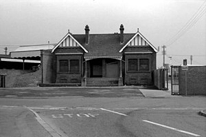
Antrim railway station (Great Northern Railway)
Appearance
Antrim GN (I) | |
|---|---|
 | |
| General information | |
| Location | Station Rd., Antrim, County Antrim Northern Ireland |
| Other information | |
| Status | Disused |
| History | |
| Pre-grouping | Great Northern Railway (Ireland) |
| Key dates | |
| 13 November 1871 | Station opened |
| 12 September 1960 | Station closed |
Antrim railway station (Great Northern) served Antrim in County Antrim, Northern Ireland. It was located on the mothballed Lisburn-Antrim railway line. The town is now served by Antrim railway station.
History
Built by the Dublin and Antrim Junction Railway, it became part of the Great Northern Railway (Ireland) . In 1958 it passed to the Ulster Transport Authority. The UTA closed the station two years later.
The site today
Currently, the line between Antrim and Lisburn is only used for training and emergency diversions, however it could be revived under plans to operate a Belfast - Lisburn - Antrim - Belfast circular route. Any traffic would use the current Antrim station.
| Preceding station | Disused railways | Following station | ||
|---|---|---|---|---|
| Millars Bridge | Great Northern Railway (Ireland) Lisburn-Antrim |
Antrim Junction |
References
- Butt, R. V. J. (October 1995). The Directory of Railway Stations: details every public and private passenger station, halt, platform and stopping place, past and present (1st ed.). Sparkford: Patrick Stephens Ltd. ISBN 978-1-85260-508-7. OCLC 60251199. OL 11956311M.
- Jowett, Alan (2000). Jowett's Nationalised Railway Atlas (1st ed.). Penryn, Cornwall: Atlantic Transport Publishers. ISBN 978-0-906899-99-1. OCLC 228266687.
54°43′05″N 6°12′43″W / 54.718°N 6.212°W
