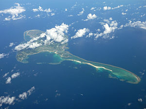
Kume Island
Appearance
Native name: クミジマ(Kumijima) | |
|---|---|
 Kumejima Island 2009 | |
 | |
| Geography | |
| Location | Pacific Ocean |
| Coordinates | 26°20′28″N 126°48′18″E / 26.34111°N 126.80500°E |
| Archipelago | Okinawa Islands |
| Area | 59.11 km2 (22.82 sq mi) |
| Administration | |
Japan | |
| Prefecture | Okinawa Prefecture |
| Demographics | |
| Population | 8,713 (2010) |
| Ethnic groups | Ryukyuan, Japanese |
Kume Island[1] (久米島, Kumejima, Okinawan: クミジマ Kumijima) is an island, part of the Okinawa Islands and administratively part of the town of Kumejima, Okinawa Prefecture, Japan. It has an area of 59.11 square kilometres (636,300,000 sq ft).[2] The island had a population of 8,713 (2010).
Kume Island is a volcanic island. Its principal economic activities are the production of sugarcane and tourism.[3]
Climate
| Climate data for Kumejima (1991−2020 normals, extremes 1958−present) | |||||||||||||
|---|---|---|---|---|---|---|---|---|---|---|---|---|---|
| Month | Jan | Feb | Mar | Apr | May | Jun | Jul | Aug | Sep | Oct | Nov | Dec | Year |
| Record high °C (°F) | 27.4 (81.3) |
27.0 (80.6) |
28.7 (83.7) |
30.2 (86.4) |
32.1 (89.8) |
33.7 (92.7) |
34.7 (94.5) |
35.3 (95.5) |
34.5 (94.1) |
32.7 (90.9) |
30.2 (86.4) |
29.4 (84.9) |
35.3 (95.5) |
| Mean daily maximum °C (°F) | 19.5 (67.1) |
20.0 (68.0) |
21.8 (71.2) |
24.3 (75.7) |
27.0 (80.6) |
29.9 (85.8) |
32.0 (89.6) |
31.8 (89.2) |
30.5 (86.9) |
27.9 (82.2) |
24.9 (76.8) |
21.4 (70.5) |
25.9 (78.6) |
| Daily mean °C (°F) | 17.0 (62.6) |
17.3 (63.1) |
19.0 (66.2) |
21.5 (70.7) |
24.2 (75.6) |
27.2 (81.0) |
29.0 (84.2) |
28.9 (84.0) |
27.7 (81.9) |
25.3 (77.5) |
22.4 (72.3) |
19.0 (66.2) |
23.2 (73.8) |
| Mean daily minimum °C (°F) | 14.6 (58.3) |
14.8 (58.6) |
16.3 (61.3) |
19.0 (66.2) |
21.8 (71.2) |
25.1 (77.2) |
26.7 (80.1) |
26.5 (79.7) |
25.3 (77.5) |
23.2 (73.8) |
20.3 (68.5) |
16.6 (61.9) |
20.8 (69.5) |
| Record low °C (°F) | 2.9 (37.2) |
4.0 (39.2) |
3.2 (37.8) |
6.8 (44.2) |
12.9 (55.2) |
16.4 (61.5) |
20.4 (68.7) |
19.8 (67.6) |
15.5 (59.9) |
11.6 (52.9) |
9.0 (48.2) |
5.4 (41.7) |
2.9 (37.2) |
| Average precipitation mm (inches) | 138.3 (5.44) |
141.2 (5.56) |
195.5 (7.70) |
196.8 (7.75) |
260.3 (10.25) |
307.4 (12.10) |
154.4 (6.08) |
197.7 (7.78) |
235.6 (9.28) |
152.7 (6.01) |
129.6 (5.10) |
134.0 (5.28) |
2,243.5 (88.33) |
| Average precipitation days (≥ 1.0 mm) | 12.7 | 11.7 | 13.0 | 11.5 | 12.0 | 11.2 | 7.9 | 9.8 | 10.6 | 8.6 | 9.0 | 10.7 | 128.7 |
| Average relative humidity (%) | 68 | 70 | 73 | 76 | 80 | 84 | 80 | 80 | 78 | 73 | 70 | 68 | 75 |
| Mean monthly sunshine hours | 75.2 | 80.1 | 107.6 | 118.4 | 136.2 | 158.9 | 250.3 | 231.9 | 198.6 | 162.3 | 108.3 | 89.9 | 1,717.8 |
| Source: Japan Meteorological Agency[4][5] | |||||||||||||
See also
References
- ^ Kerama Islands. Open Coast Travel.
- ^ "沖縄の島面積". Archived from the original on 2011-07-25. Retrieved 2011-07-19.
- ^ "Kumejima". Encyclopedia of Japan. Tokyo: Shogakukan. 2013. OCLC 56431036. Archived from the original on 2007-08-25. Retrieved 2013-01-27.
- ^ 観測史上1~10位の値(年間を通じての値). JMA. Retrieved March 17, 2022.
- ^ 気象庁 / 平年値(年・月ごとの値). JMA. Retrieved March 17, 2022.
