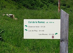
Col de la Ramaz
Appearance
| Col de la Ramaz | |
|---|---|
 | |
| Elevation | 1,559 m (5,115 ft) |
| Location | Haute-Savoie, France |
| Range | Alps |
| Coordinates | 46°9′48″N 6°34′29″E / 46.16333°N 6.57472°E |
Col de la Ramaz (pronounced with a silent z "Ramá") (elevation 1559 m.) is a high mountain pass in the Alps in the department of Haute-Savoie in France through which the Tour de France passed during 2003, 2010, 2016 and the 2023 race).[1][2][3] The road through the pass culminates slightly higher, at 1619m (5312 feet).
Appearances in the Tour de France
| Year | Stage | Category | Start | Finish | Leader at the summit |
|---|---|---|---|---|---|
| 2023 | 14 | 1 | Annemasse | Morzine | |
| 2016 | 20 | 1 | Megève | Morzine | |
| 2010 | 8 | 1 | Station des Rousses | Morzine-Avoriaz | |
| 2003 | 7 | 1 | Lyon | Morzine | |
| 1981 | 16 | 1 | Thonon-les-Bains | Morzine |
See also
References
- ^ Will (9 July 2010). "Tour de France preview cycling Col de la Ramaz". Cycling Challenge. Retrieved 19 July 2015.
- ^ "Stage 20 - Megève > Morzine-Avoriaz - Tour de France 2016". Archived from the original on 2016-07-01. Retrieved 2016-10-21.
- ^ "Le col de la Ramaz dans le Tour de France". www.ledicodutour.com (in French). Retrieved 2022-08-08.
