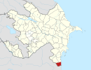
Sım
Appearance
Sım | |
|---|---|
Municipality | |
| Coordinates: 38°29′30″N 48°38′56″E / 38.49167°N 48.64889°E | |
| Country | |
| Rayon | Astara |
| Population | |
• Total | 582 |
| Time zone | UTC+4 (AZT) |
| • Summer (DST) | UTC+5 (AZT) |
Sim is a village in the administrative territorial unit of Astara district of the Republic of Azerbaijan.
Gallery
[edit]
References
[edit]


