Ellikqala District
Appearance
Ellikqala District | |
|---|---|
 | |
| Country | |
| Autonomous Republic | Karakalpakstan |
| Capital | Boʻston |
| Area | |
• Total | 5,420 km2 (2,090 sq mi) |
| Population (2022) | |
• Total | 164,600 |
| • Density | 30/km2 (79/sq mi) |
| Time zone | UTC+5 (UZT) |
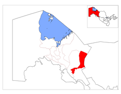
Ellikqala District (Template:Lang-uz, Template:Lang-kaa) is a district of Karakalpakstan in Uzbekistan. The capital lies at the city Boʻston.[1] Its area is 5,420 km2 (2,090 sq mi)[2] and it had 164,600 inhabitants in 2022.[3]
There is one city (Boʻston), one town (Saxtiyon) and 13 rural communities (Amirobod, Guldursun, Guliston, Navoiy, Oqchakoʻl, Sarabiy, Tozabogʻ, Sharq Yulduzi, Ellikqalʼa, Qizilqum, Qilchinoq, Qirqqiz, Doʻstlik).
The district takes its name from the Elliq Qala (Karakalpak fifty fortresses), a series of ancient desert castles in the district.
References
- ^ "Classification system of territorial units of the Republic of Uzbekistan" (in Uzbek and Russian). The State Committee of the Republic of Uzbekistan on statistics. July 2020.
- ^ "Qoraqalpog'iston Respublikasining ma'muriy-hududiy bo'linishi" [Administrative-territorial division of the Republic of Karakalpakstan] (PDF) (in Uzbek). Karakalpakstan Republic department of statistics.
- ^ "Hududlar bo'yicha shahar va qishloq aholisi soni" [Urban and rural population by district] (PDF) (in Uzbek). Karakalpakstan Republic department of statistics.

