Pas de Cheville
Appearance
| Pas de Cheville | |
|---|---|
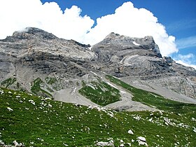
 The Diablerets as seen from Pas de Cheville | |
| Elevation | 2,038 m (6,686 ft) |
| Traversed by | Trail |
| Location | Switzerland |
| Range | Alps |
| Coordinates | 46°17′14″N 7°11′30″E / 46.28722°N 7.19167°E |
The Pas de Cheville (2038 m) (also the Col de Cheville) is a high mountain pass across the western Bernese Alps, connecting Gryon in the canton of Vaud in Switzerland and Derborence in the canton of Valais.
The pass lies between Les Diablerets in the north and Tête à Pierre Grept, Grand Muveran to the south .
See also
External links
