
West Lawn Heights Historic District
West Lawn Heights Historic District | |
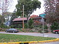
 Houses on Hillington Way | |
  | |
| Location | Roughly bounded by Virginia Ter., Regent St., S. Spooner Ave., and Illinois Central Railroad, Madison, Wisconsin |
|---|---|
| Coordinates | 43°3′56″N 89°25′26″W / 43.06556°N 89.42389°W |
| Area | 77 acres (31 ha) |
| NRHP reference No. | 98000223[1] |
| Added to NRHP | March 5, 1998 |
West Lawn Heights Historic District is located in Madison, Wisconsin. It was added to the National Register of Historic Places in 1998.[2]
History
Contributing buildings in the district were constructed from 1906 to 1946.[3] Most of those were built in 1913 and after.
Gallery
-
 Houses on Hillington Green
 -
 Houses on Rowley Avenue


References
- ^ "National Register Information System". National Register of Historic Places. National Park Service. July 9, 2010.
- ^ "West Lawn Heights Historic District". Landmark Hunter.com. Retrieved 2012-02-08.
- ^ "West Lawn Heights Historic District". Wisconsin Historical Society. Retrieved 2012-02-08.