Alger Falls
Appearance
| Alger Falls | |
|---|---|
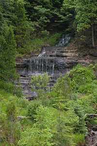
 View of Alger Falls from M-28 | |
 | |
| Location | Alger County, Michigan |
| Coordinates | 46°23′35″N 86°38′50″W / 46.39295°N 86.64722°W |
| Total height | 15 feet (4.6 m) |
| Watercourse | Alger Creek |
Alger Falls is a waterfall located along highway M-28 (Michigan highway) in Alger County, Michigan near Munising at the junction with M-94. The falls consist of a series of drops, the highest of which is about 15 feet (4.6 m). The falls can be seen from the highway. The level of water coming over the falls can vary greatly depending on snow melt or rainfall.
 |
 |
References
Wikimedia Commons has media related to Alger Falls.
