
Garni Gorge
40°07′10″N 44°43′23″E / 40.11944°N 44.72306°E

The Garni Gorge is situated 23 km east of Yerevan, Armenia, just below the village with the same name. On a promontory above the gorge the first-century AD Garni temple may be seen. Along the sides of the gorge are cliff walls of well-preserved basalt columns, carved out by the Goght River. This portion of the Garni Gorge is typically referred to as the "Symphony of the Stones." It is most easily reached via a road that leads left down the gorge just before reaching the temple of Garni. Another road leads to the gorge through the village, down a cobblestone road, and into the valley. Once in the valley, turning right will lead to Garni Gorge, an 11th-century medieval bridge, and the "Symphony of the Stones". Taking a left will lead along the river past a fish hatchery, up to the Khosrov Forest State Reserve, and a little further Havuts Tar Monastery.
Gallery
-
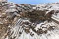 Example of basalt columns ("Symphony of the Stones") along Garni gorge
 -
 The stones
 -
 Garni valley
 -
 Garni stream


References
- Kiesling, Brady (2005), Rediscovering Armenia: Guide, Yerevan, Armenia: Matit Graphic Design Studio
External links
This Armenia location article is a stub. You can help Wikipedia by expanding it. |