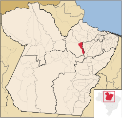
Bagre, Pará
Appearance
Bagre | |
|---|---|
Municipality | |
 Location in the State of Pará | |
| Coordinates: 01°54′00″S 50°09′50″W / 1.90000°S 50.16389°W | |
| Country | |
| Region | North |
| State | |
| Area | |
| • Total | 4,397.290 km2 (1,697.803 sq mi) |
| Elevation | 31 m (102 ft) |
| Population (2008) | |
| • Total | 19,780 |
| • Density | 3.1/km2 (8/sq mi) |
| Time zone | UTC-3 (BST) |
| Postal Code | 68475-000 |
Bagre is a Brazilian municipality located in the state of Pará. Its population as of 2008 is estimated to be 19,780 people. The area of the municipality is 4,397.290 km². The city belongs to the mesoregion Marajó and to the microregion of Portel.


