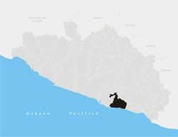
San Marcos Municipality, Guerrero
Appearance
San Marcos | |
|---|---|
 San Marcos in Guerrero | |
| Coordinates: 17°25′N 99°20′W / 17.417°N 99.333°W | |
| Country | |
| State | Guerrero |
| Municipal seat | San Marcos, Guerrero |
| Founded | 28 September 1885 |
| Area | |
• Total | 960.7 km2 (370.9 sq mi) |
| Elevation | 30 m (100 ft) |
| Population (2005) | |
• Total | 44,959 |
San Marcos is one of the 81 municipalities of the Mexican state of Guerrero. Its municipal seat is the town of San Marcos.
The municipality of San Marcos covers an area of 960.7 km² and is home to approximately 50 000 inhabitants. Ethnically, the population is mainly indigenous with a considerable mixing with African and to a lesser extent, European settlers. It comprises 138 villages and towns, examples of which include El Cortes, Las Vigas, El Cerro, Vista Hermosa, Tecomate de Pesqueria, Monte Alto, Santo Domingo, Las Ramaditas and others.

