Pcim
Pcim | |
|---|---|
Village | |
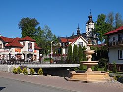
 Center of the village | |
| Coordinates: 49°45′N 19°58′E / 49.750°N 19.967°E | |
| Country | |
| Voivodeship | Lesser Poland |
| County | Myślenice |
| Gmina | Pcim |
| Population | 4,900 |
Pcim [pt͡ɕim] is a village in Myślenice County, Lesser Poland Voivodeship, in southern Poland. It seats in gmina (administrative district) called Gmina Pcim.[1] It lies approximately 10 kilometres (6 mi) south of Myślenice and 35 km (22 mi) south of the regional capital Kraków. The village, which is located along the European route E77, has a population of approximately 4,900, and is divided into three districts: Pcim Centrum, Pcim Krzywica, and Pcim Sucha. The name Pcim is sometimes used in Polish in fictional contexts as a slightly comic-sounding town or village name. John Cleese said in a Polish Bank Zachodni WBK TV advertisement that his aunt was from Pcim.
First settlers came here in the early 13th century, invited by Prince of Kraków Leszek Biały. In 1338, King Kazimierz Wielki founded here parish church of St. Nicholas. At that time, the village belonged to a Czech knight named Nedan, hence its name Nedanowa Wola. According to a 1629 document, Pcim had two mills. In the Polish September Campaign, soldiers of the 10th Motorized Cavalry Brigade fought here defensive battles with the advancing Wehrmacht. During the war, Pcim was an important center of the Home Army. The village was flooded in the 2010 Central European floods.

