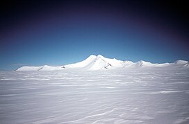
Mount Charity
Appearance
| Mount Charity | |
|---|---|
 Mount Charity view from east | |
| Highest point | |
| Elevation | 2,680 m (8,790 ft)[1] |
| Coordinates | 69°54′S 64°34′W / 69.900°S 64.567°W[1] |
| Geography | |
| Parent range | Eternity Range |
Mount Charity is mountain in Antarctica. It lies 9 nautical miles (17 km) south of Mount Hope, rising 2,680 metres (8,800 ft) from the south end of the Eternity Range in northern Palmer Land. It was first seen from the air and named by Lincoln Ellsworth during his flights of November 21 and 23, 1935. It was surveyed by John Riddoch Rymill of the British Graham Land Expedition in November 1936. The mountain was subsequently photographed from the air by the United States Antarctic Service in September 1940, and by the Ronne Antarctic Research Expedition in December 1947. The feature is one of three major mountains in Ellsworth's Eternity Range to which he gave the names Faith, Hope and Charity.[1]
References
- ^ a b c "Charity, Mount". Geographic Names Information System. United States Geological Survey, United States Department of the Interior. Retrieved 2011-11-03.

