
Papowo Biskupie
Papowo Biskupie | |
|---|---|
Village | |
.jpg) Ruins of the castle | |
 Coat of arms | |
 Papowo Biskupie | |
| Coordinates: 53°15′N 18°34′E / 53.250°N 18.567°E | |
| Country | |
| Voivodeship | Kuyavian-Pomeranian |
| County | Chełmno |
| Gmina | Papowo Biskupie |
| Population | 720 |
Papowo Biskupie [paˈpɔvɔ bisˈkupjɛ] (German: Bischöflich Papau) is a village in Chełmno County, Kuyavian-Pomeranian Voivodeship, in north-central Poland.[1] It is the seat of the gmina (administrative district) called Gmina Papowo Biskupie. It lies 17 kilometres (11 mi) south-east of Chełmno and 25 km (16 mi) north of Toruń. In village is castle Teutonic and Gothic church.
The village has a population of 720.
Gallery
-
 Figure by the cemetery
 -
 Cemetery
 -
 Fire brigade in Papowo
 -
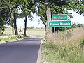 Road sign - border between Wrocławki and Papowo Biskupie
 -
 Road signs - border between Papowo Biskupie and Nowy Dwór Królewski
 -
 A morgue.
 -
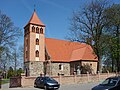 Church of St. Nicholas, built in the 13th century.
 -
 A playground.
 -
 Church, main entry.


Photos of the castle


References
Wikimedia Commons has media related to Papowo Biskupie.
| Seat | ||
|---|---|---|
| Other villages | ||
53°15′N 18°34′E / 53.250°N 18.567°E
This Chełmno County location article is a stub. You can help Wikipedia by expanding it. |