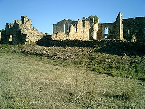
Monastery of Santa Maria del Roure

The monastery of Santa María del Roure, referred to as El Roure by locals, is a ruined monastery to the northwest of Pont de Molins (Alt Empordà) at the top of the Sierra de los Tramonts. Mostly Gothic-era portions of the building are preserved. Dedicated to the Virgin Mary, the various names of the sanctuary -Santa María del Roure, Canónica de Santa María del Roure, Monastery of Santa María del Roure, or according to the Cartographic Institute of Catalonia: Mare de Deu del Roure- date from the 11th or early 12th century. This building is indexed in the Catalan heritage register as Bé Cultural d'Interès Local (BCIL) under the reference IPA-19985.
Bibliography
- Del Campo and Jordan Ferran (2000). Set segles d'una família empordanesa, els Jordà de Molins. Figueras BRAU editions. ISBN 84-88589-70-0 (in Catalan).
- Vivas Llorens, Edward (1992). Guerra Gran, la batalla del Roure i el seu santuari pp. 109-148. Annals of the Institute of Empordanesos, 25. (in Catalan).
- Volume 3 (2005). El Meu País, tots els pobles, viles i ciutats de Cataluna. Barcelona, Editions 62. ISBN 9788429755701 (in Catalan).
External links
 Media related to Canònica de Santa Maria del Roure at Wikimedia Commons
42°19′27″N 2°54′40″E / 42.324263°N 2.911191°E
