Chūō-ku, Kumamoto

Coordinates: 32°48′12″N 130°42′29″E / 32.8033°N 130.7081°E / 32.8033; 130.7081
From Wikipedia, the free encyclopedia

This is an old revision of this page, as edited by Ser Amantio di Nicolao (talk | contribs) at 06:36, 5 January 2018 (Moving from Category:Wards of Kumamoto, Kumamoto to Category:Wards of Kumamoto using Cat-a-lot). The present address (URL) is a permanent link to this revision, which may differ significantly from the current revision.

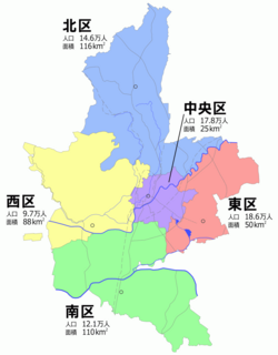
Map of Kumamoto's Wards
Chūō ward office is located beside the Kumamoto City Office.

Chūō-ku (中央区) is one of the five wards of Kumamoto City, Japan. The ward is located in the center of the city.

As of 2012, it has a population of 183,497 people and an area of 25.33 km2.

External links

Media related to Chūō-ku, Kumamoto at Wikimedia Commons

32°48′12″N 130°42′29″E / 32.8033°N 130.7081°E / 32.8033; 130.7081